1
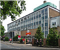
Sorting office, Thorpe Road, Norwich
"A good example of mid-1950s architecture, nicely grouped and with much curtain-walling. It deserves mention in a town at that moment poor in worthwhile C20 buildings". By T.F. Winterburn of the Ministry of Works, 1955-56.
Pevsner appears not to recognise Norwich's status as a city.
Image: © Stephen Richards
Taken: 17 Jun 2013
0.01 miles
2
Norwich Mail Centre
The Royal Mail building on Thorpe Road, the A1242.
Image: © Mary and Angus Hogg
Taken: 30 Aug 2021
0.01 miles
3
Royal mail Building, Norwich
Image: © Richard Rogerson
Taken: 5 Oct 2011
0.01 miles
4
13-17 Thorpe Road - Norwich Mail Centre
For another view and some information see > https://www.geograph.org.uk/photo/6259166.
Image: © Evelyn Simak
Taken: 5 Sep 2019
0.01 miles
5
13-17 Thorpe Road - Norwich Mail Centre (Royal coat of arms)
See > https://www.geograph.org.uk/photo/6259185 for a wider view of this location and > https://www.geograph.org.uk/photo/6259166 for a full view of this building and some information.
Image: © Evelyn Simak
Taken: 5 Sep 2019
0.01 miles
6
13-17 Thorpe Road - Norwich Mail Centre
The site is 1.52 hectares in size and located on the south side of Thorpe Road (A1242), a busy and heavily trafficked radial route serving the eastern part of the city. The frontages are to Thorpe Road, Lower Clarence Road and Stracey Road. The building is currently occupied and operated by Royal Mail Group and accommodates Royal Mail’s Norwich sorting office, ancillary office and storage uses as well as vehicle parking. The substantial main building dates from the 1950s.
The Norwich City Council's website informs that "The existing mail centre site is proposed for redevelopment subject to the relocation of Royal Mail’s operational facilities, which is planned to take place during the plan period. The opportunity exists for a high density, high quality mixed use redevelopment in an established zone of offices and housing which is well related to the city centre, taking advantage of its location on a public transport corridor."
Image: © Evelyn Simak
Taken: 5 Sep 2019
0.01 miles
7
13-17 Thorpe Road - Norwich Mail Centre
Note the Royal coat of arms > https://www.geograph.org.uk/photo/6259186. For a full view of this building and some information see > https://www.geograph.org.uk/photo/6259166.
Image: © Evelyn Simak
Taken: 5 Sep 2019
0.01 miles
8
Norwich Mail Centre - WW1 and WW2 memorial tablets
For a full view of this building and some information see > https://www.geograph.org.uk/photo/6259166.
Image: © Evelyn Simak
Taken: 5 Sep 2019
0.01 miles
9
13-17 Thorpe Road - Norwich Mail Centre
The site is 1.52 hectares in size and located on the south side of Thorpe Road (A1242), a busy and heavily trafficked radial route serving the eastern part of the city. The frontages are to Thorpe Road, Lower Clarence Road and Stracey Road. The building is currently occupied and operated by Royal Mail Group and accommodates Royal Mail’s Norwich sorting office, ancillary office and storage uses as well as vehicle parking. The substantial main building dates from the 1950s.
The Norwich City Council's website informs that "The existing mail centre site is proposed for redevelopment subject to the relocation of Royal Mail’s operational facilities, which is planned to take place during the plan period. The opportunity exists for a high density, high quality mixed use redevelopment in an established zone of offices and housing which is well related to the city centre, taking advantage of its location on a public transport corridor."
Image: © Evelyn Simak
Taken: 5 Sep 2019
0.01 miles
10
Norwich Mail Centre
Conveniently situated next to the railway.
Image: © Bill Boaden
Taken: 30 Dec 2013
0.01 miles


