IMAGES TAKEN NEAR TO
Beechlands, NORWICH, NR8 6SZ
Introduction
This page details the photographs taken nearby to Beechlands, NR8 6SZ by members of the Geograph project.
The Geograph project started in 2005 with the aim of publishing, organising and preserving representative images for every square kilometre of Great Britain, Ireland and the Isle of Man.

There are currently over 7.5m images from over14,400 individuals and you can help contribute to the project by visiting https://www.geograph.org.uk
Image Map
Images are licensed for reuse under creativecommons.org/licenses/by-sa/2.0
Notes
- Clicking on the map will re-center to the selected point.
- The higher the marker number, the further away the image location is from the centre of the postcode.
Image Listing (11 Images Found)
Images are licensed for reuse under creativecommons.org/licenses/by-sa/2.0
Image
Details
Distance
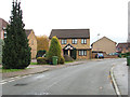
1
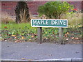
Maple Drive sign
On Maple Drive at the junction with Beech Avenue
Image: © Geographer
Taken: 26 Sep 2013
0.10 miles
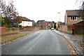
2
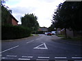
Maple Drive, Taverham
At the junction with Beech Avenue
Image: © Geographer
Taken: 26 Sep 2013
0.10 miles
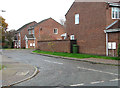
3
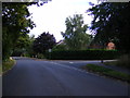
Beech Avenue, Taverham
At the junction with Maple Drive
Road no.C262
Image: © Geographer
Taken: 26 Sep 2013
0.10 miles
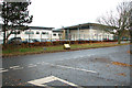
8
Taverham High School
New Sports Facility under construction
Image: © Ian Robertson
Taken: 25 Feb 2007
0.18 miles
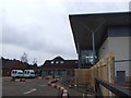
10
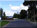
Beech Avenue, Taverham
At the entrance to Wensum Valley Hotel
Road no.C262
http://www.wensumvalleyhotel.co.uk/
Image: © Geographer
Taken: 26 Sep 2013
0.20 miles