IMAGES TAKEN NEAR TO
Drayton Hall Park, NORWICH, NR8 6HE
Introduction
This page details the photographs taken nearby to Drayton Hall Park, NR8 6HE by members of the Geograph project.
The Geograph project started in 2005 with the aim of publishing, organising and preserving representative images for every square kilometre of Great Britain, Ireland and the Isle of Man.

There are currently over 7.5m images from over14,400 individuals and you can help contribute to the project by visiting https://www.geograph.org.uk
Image Map (Loading...)


Getting Data...Please wait
Leaflet Map data © OpenStreetMap
Images are licensed for reuse under creativecommons.org/licenses/by-sa/2.0
Notes
- Clicking on the map will re-center to the selected point.
- The higher the marker number, the further away the image location is from the centre of the postcode.
Image Listing (8 Images Found)
Images are licensed for reuse under creativecommons.org/licenses/by-sa/2.0
Image
Details
Distance
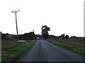
1
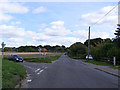
Hall Lane, Drayton
At the junction with Drayton Lane
Road no.C282
Image: © Geographer
Taken: 26 Sep 2013
0.15 miles
2
Drayton Lane, Drayton
At the junction with Hall Lane
Road no.C282
Image: © Geographer
Taken: 26 Sep 2013
0.16 miles
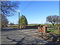
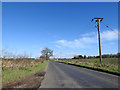
3
Drayton Lane, Drayton
Near the junction with Hall Lane
Road no.C282
Image: © Geographer
Taken: 26 Sep 2013
0.17 miles
5
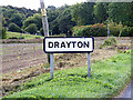
Drayton Village Name sign on Drayton Road
Approaching the junction with Hall Lane
Road no.C282
Image: © Geographer
Taken: 26 Sep 2013
0.22 miles
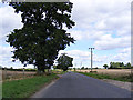
6
Entering Drayton on Drayton Lane
Approaching the junction with Hall Lane
Road no.C282
Image: © Geographer
Taken: 26 Sep 2013
0.22 miles
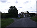
8
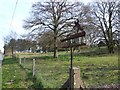
Old Hill, Hall Road, Drayton
Sign at the start of the driveway to the house on the hill, on the right.
Image: © Ian Robertson
Taken: 5 Apr 2007
0.24 miles