IMAGES TAKEN NEAR TO
Bill Todd Way, NORWICH, NR8 6GF
Introduction
This page details the photographs taken nearby to Bill Todd Way, NR8 6GF by members of the Geograph project.
The Geograph project started in 2005 with the aim of publishing, organising and preserving representative images for every square kilometre of Great Britain, Ireland and the Isle of Man.

There are currently over 7.5m images from over14,400 individuals and you can help contribute to the project by visiting https://www.geograph.org.uk
Image Map
Images are licensed for reuse under creativecommons.org/licenses/by-sa/2.0
Notes
- Clicking on the map will re-center to the selected point.
- The higher the marker number, the further away the image location is from the centre of the postcode.
Image Listing (13 Images Found)
Images are licensed for reuse under creativecommons.org/licenses/by-sa/2.0
Image
Details
Distance

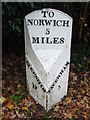
2
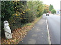
Old Milepost
Old milepost on the A.1067 at Taverham, Norfolk.. For close up view see http://www.geograph.org.uk/photo/1558876
Image: © Keith Evans
Taken: 28 Oct 2009
0.20 miles
3
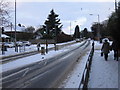
Taverham, Norfolk
Snowy day in Taverham, Norfolk. 9 Jan 2010
Image: © Jeremy Osborne
Taken: 9 Jan 2010
0.20 miles
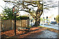
4
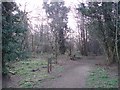
The entrance to Spring Plantation
The track leading south from A1067 into Spring Plantation, Taverham.
Image: © David Robertson
Taken: 14 Mar 2007
0.20 miles
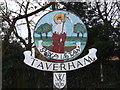
5
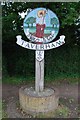
Village sign
The village sign at Taverham, Norfolk
Image: © Craig Tuck
Taken: 19 Jul 2009
0.20 miles
6
Taverham village sign
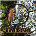
A replacement sign erected in 2012. The chappie with scythe in hand cutting the poppies and wheat with the sun at his back is St. Walstan. Having been born at Bawburgh or Blythburgh, (depending on which version you read) into a rich Saxon family he decided that he’d rather be a farm-worker at Taverham and earn an honest living. While working in the fields he had a revelation and found religion. He is buried at Bawburgh, where a special service is held annually on or near 30th of May, since he is the patron saint of agricultural workers and can be recognised by his scythe. The church and River Wensum also feature on the sign. https://www.geograph.org.uk/photo/6689318
Image: © Adrian S Pye
Taken: 26 Nov 2020
0.20 miles
7
Taverham village sign
A replacement sign erected in 2012. The chappie with scythe in hand cutting the poppies and wheat with the sun at his back is St. Walstan. Having been born at Bawburgh or Blythburgh, (depending on which version you read) into a rich Saxon family he decided that he’d rather be a farm-worker at Taverham and earn an honest living. While working in the fields he had a revelation and found religion. He is buried at Bawburgh, where a special service is held annually on or near 30th of May, since he is the patron saint of agricultural workers and can be recognised by his scythe. The church and River Wensum also feature on the sign https://www.geograph.org.uk/photo/6689316.
Image: © Adrian S Pye
Taken: 26 Nov 2020
0.20 miles
9
Old Milepost
Old milepost on the A.1067 at Taverham, Norfolk.. For overall view see http://www.geograph.org.uk/photo/1558872
Image: © Keith Evans
Taken: 28 Oct 2009
0.24 miles
10
The Cains off Kingswood Avenue, Taverham
Image: © Adrian S Pye
Taken: 15 Jul 2015
0.24 miles