IMAGES TAKEN NEAR TO
Cozens-Hardy Road, NORWICH, NR7 8QG
Introduction
This page details the photographs taken nearby to Cozens-Hardy Road, NR7 8QG by members of the Geograph project.
The Geograph project started in 2005 with the aim of publishing, organising and preserving representative images for every square kilometre of Great Britain, Ireland and the Isle of Man.

There are currently over 7.5m images from over14,400 individuals and you can help contribute to the project by visiting https://www.geograph.org.uk
Image Map
Images are licensed for reuse under creativecommons.org/licenses/by-sa/2.0
Notes
- Clicking on the map will re-center to the selected point.
- The higher the marker number, the further away the image location is from the centre of the postcode.
Image Listing (4 Images Found)
Images are licensed for reuse under creativecommons.org/licenses/by-sa/2.0
Image
Details
Distance
1
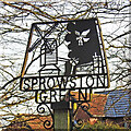
Sprowston Green village sign
The sign which is identical to the Sprowston sign apart from the name, shows the old postmill, so often painted by John Crome, before it was destroyed by fire in 1933. The church of St Margaret nestles in the bottom corner and above is the emblem of the Corbett family a Raven or Corvus corax, otherwise called a corbie. https://www.geograph.org.uk/photo/6738300
Image: © Adrian S Pye
Taken: 25 Jan 2021
0.22 miles
2
Sprowston Green village sign
The sign which is identical to the Sprowston sign apart from the name, shows the old postmill, so often painted by John Crome, before it was destroyed by fire in 1933. The church of St Margaret nestles in the bottom corner and above is the emblem of the Corbett family a Raven or Corvus corax, otherwise called a corbie. https://www.geograph.org.uk/photo/6738299
Image: © Adrian S Pye
Taken: 25 Jan 2021
0.22 miles
4
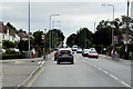
Pedestrian-Controlled Traffic Lights on Wroxham Road
Image: © David Dixon
Taken: 7 Aug 2015
0.24 miles