IMAGES TAKEN NEAR TO
Windsor Park Gardens, NORWICH, NR6 7PR
Introduction
This page details the photographs taken nearby to Windsor Park Gardens, NR6 7PR by members of the Geograph project.
The Geograph project started in 2005 with the aim of publishing, organising and preserving representative images for every square kilometre of Great Britain, Ireland and the Isle of Man.

There are currently over 7.5m images from over14,400 individuals and you can help contribute to the project by visiting https://www.geograph.org.uk
Image Map
Images are licensed for reuse under creativecommons.org/licenses/by-sa/2.0
Notes
- Clicking on the map will re-center to the selected point.
- The higher the marker number, the further away the image location is from the centre of the postcode.
Image Listing (10 Images Found)
Images are licensed for reuse under creativecommons.org/licenses/by-sa/2.0
Image
Details
Distance
1
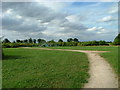
Public Park and play area
At Windsor Park Gardens, Norwich.
Image: © Dave Fergusson
Taken: 18 Aug 2012
0.06 miles
2
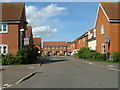
Windsor Park Gardens, Norwich
Looking north from White Woman Lane.
Image: © Dave Fergusson
Taken: 18 Aug 2012
0.08 miles
3
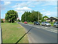
North Walsham Road, Norwich
Looking north from its junction with White Woman Lane.
Image: © Dave Fergusson
Taken: 18 Aug 2012
0.08 miles
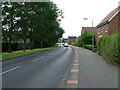
4
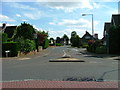
Proctor road, Norwich
Looking north from the roundabout on White Woman Lane.
Image: © Dave Fergusson
Taken: 18 Aug 2012
0.13 miles
5
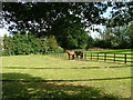
Horses at Oak Lodge
Viewed from North Walsham Road.
Image: © Dave Fergusson
Taken: 18 Aug 2012
0.15 miles
7
Field between Church Lane and the B1150 road
The house seen in the background is situated on the B1150. Church Lane used to be a public road connecting with Beeston Lane further to the north. Gates now block vehicular access at both ends.
Image: © Evelyn Simak
Taken: 6 Sep 2010
0.22 miles
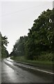
9

Woodland by North Walsham Road, Old Catton
Image: © David Howard
Taken: 7 Jul 2024
0.23 miles
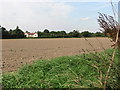
10

Cultivated field west of Church Lane
The property seen in the background is situated on the B1150 road north of Sprowston.
Image: © Evelyn Simak
Taken: 6 Sep 2010
0.25 miles