IMAGES TAKEN NEAR TO
Hurricane Way, NORWICH, NR6 6JB
Introduction
This page details the photographs taken nearby to Hurricane Way, NR6 6JB by members of the Geograph project.
The Geograph project started in 2005 with the aim of publishing, organising and preserving representative images for every square kilometre of Great Britain, Ireland and the Isle of Man.

There are currently over 7.5m images from over14,400 individuals and you can help contribute to the project by visiting https://www.geograph.org.uk
Image Map
Images are licensed for reuse under creativecommons.org/licenses/by-sa/2.0
Notes
- Clicking on the map will re-center to the selected point.
- The higher the marker number, the further away the image location is from the centre of the postcode.
Image Listing (9 Images Found)
Images are licensed for reuse under creativecommons.org/licenses/by-sa/2.0
Image
Details
Distance
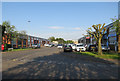
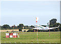
1
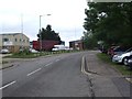
Hurricane Way, Norwich Airport Industrial Estate
Image: © Ian Robertson
Taken: 17 May 2007
0.03 miles
4
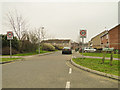
Evans Way, Old Catton, Norwich
Part of a relatively new housing complex near Norwich Airport
Image: © Adrian S Pye
Taken: 18 Feb 2011
0.13 miles
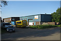
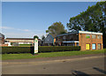
5
Meteor Close, Airport Industrial Estate
Image: © Hugh Venables
Taken: 15 May 2018
0.14 miles
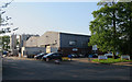
6
Hornet Court, Airport Industrial Estate
Image: © Hugh Venables
Taken: 15 May 2018
0.18 miles
7
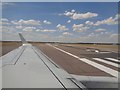
Ready for take-off!
Flybe internal flight from Norwich to Exeter.
Image: © Ashley Dace
Taken: 24 Jul 2018
0.24 miles
8
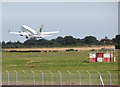
Take-off at Norwich International Airport
The aircraft is a Boeing B737-75B belonging to Germania Airlines, taking off from runway 22.
Image: © Evelyn Simak
Taken: 23 Jul 2016
0.24 miles
9
Germania Boeing B737-75B takes off from Norwich International Airport
The Germania Airlanes aircraft is taking off from runway 22.
Image: © Evelyn Simak
Taken: 23 Jul 2016
0.25 miles