IMAGES TAKEN NEAR TO
Hartbee Road, NORWICH, NR6 6GJ
Introduction
This page details the photographs taken nearby to Hartbee Road, NR6 6GJ by members of the Geograph project.
The Geograph project started in 2005 with the aim of publishing, organising and preserving representative images for every square kilometre of Great Britain, Ireland and the Isle of Man.

There are currently over 7.5m images from over14,400 individuals and you can help contribute to the project by visiting https://www.geograph.org.uk
Image Map
Images are licensed for reuse under creativecommons.org/licenses/by-sa/2.0
Notes
- Clicking on the map will re-center to the selected point.
- The higher the marker number, the further away the image location is from the centre of the postcode.
Image Listing (13 Images Found)
Images are licensed for reuse under creativecommons.org/licenses/by-sa/2.0
Image
Details
Distance
1
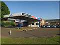
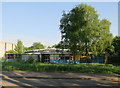
Former petrol station
Now tyre and car sales businesses.
Image: © Hugh Venables
Taken: 15 May 2018
0.05 miles
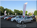
3
Hangovers gone
Former drinks wholesaler in Airport Industrial Estate, Norwich.
Image: © Hugh Venables
Taken: 15 May 2018
0.10 miles
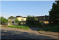
5
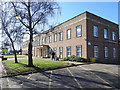
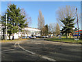
Large office block on Vulcan Road, North
Image: © Adrian S Pye
Taken: 5 Mar 2019
0.14 miles
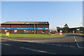
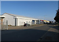
7
Booker Wholesale, Airport Industrial Estate
Image: © Hugh Venables
Taken: 15 May 2018
0.17 miles
8
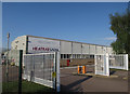
Heatrae Sadia
Factory making electric heating and hot water products. In Norwich Airport Industrial Estate.
Image: © Hugh Venables
Taken: 15 May 2018
0.20 miles
9
Eagit Training Centre closed down
Shut for over three years, previously provided engineering training.
Image: © Hugh Venables
Taken: 15 May 2018
0.21 miles
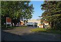
10
Airport Freight to the left
Norwich International Airport
Image: © Adrian S Pye
Taken: 5 Jan 2011
0.21 miles