IMAGES TAKEN NEAR TO
Hellesdon Road, NORWICH, NR6 5ES
Introduction
This page details the photographs taken nearby to Hellesdon Road, NR6 5ES by members of the Geograph project.
The Geograph project started in 2005 with the aim of publishing, organising and preserving representative images for every square kilometre of Great Britain, Ireland and the Isle of Man.

There are currently over 7.5m images from over14,400 individuals and you can help contribute to the project by visiting https://www.geograph.org.uk
Image Map
Images are licensed for reuse under creativecommons.org/licenses/by-sa/2.0
Notes
- Clicking on the map will re-center to the selected point.
- The higher the marker number, the further away the image location is from the centre of the postcode.
Image Listing (43 Images Found)
Images are licensed for reuse under creativecommons.org/licenses/by-sa/2.0
Image
Details
Distance
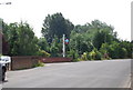
3
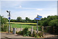
National cycleway 1 signpost, Hellesdon Rd
The route follows an old railway.
Image: © N Chadwick
Taken: 1 Jul 2010
0.03 miles
6
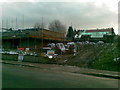
Building site Hellesdon Road, Norwich
On site of St Michael's Church
Image: © Alex McGregor
Taken: 6 Dec 2010
0.05 miles
7
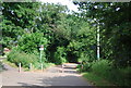
National Cycleway 1 off Hellesdon Rd
The route is Dover to John O' Groats. It follows an old railway at this point.
Image: © N Chadwick
Taken: 1 Jul 2010
0.06 miles
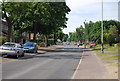
10
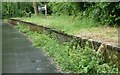
Hellesdon station on Marriott's Way
The station had a signal box by the platform, and a siding opposite with a cattle shed
Image: © David Smith
Taken: 8 Jun 2024
0.09 miles