IMAGES TAKEN NEAR TO
Dereham Road, NORWICH, NR5 8UA
Introduction
This page details the photographs taken nearby to Dereham Road, NR5 8UA by members of the Geograph project.
The Geograph project started in 2005 with the aim of publishing, organising and preserving representative images for every square kilometre of Great Britain, Ireland and the Isle of Man.

There are currently over 7.5m images from over14,400 individuals and you can help contribute to the project by visiting https://www.geograph.org.uk
Image Map
Images are licensed for reuse under creativecommons.org/licenses/by-sa/2.0
Notes
- Clicking on the map will re-center to the selected point.
- The higher the marker number, the further away the image location is from the centre of the postcode.
Image Listing (15 Images Found)
Images are licensed for reuse under creativecommons.org/licenses/by-sa/2.0
Image
Details
Distance
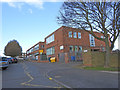
1
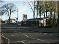
Aldi supermarket by Dereham Road, Norwich
Image: © David Smith
Taken: 16 Sep 2018
0.04 miles
2
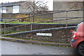
Sign for Knowland Grove, Hellsedon
Named after one of the five men of the Norfolk Regiment who were awarded the Victoria Cross. https://www.geograph.org.uk/photo/6318031
In total, six members of the Norfolk or Royal Norfolk Regiment were awarded the Victoria Cross the highest number for any one regiment.
Image: © Adrian S Pye
Taken: 8 Nov 2019
0.04 miles
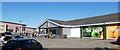
3
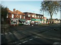
Supermarket, Earlham
The Aldi supermarket was built on the site of a notoriously rough pub, The Larkman; the area is still known as the Larkman estate and mainly consists of local authority housing.
Image: © Katy Walters
Taken: 12 Nov 2005
0.05 miles
4
Local shops, Earlham
Opposite the Aldi supermarket. The supermarket contains the local post office; the other shops are a chip shop (which has a neon sign / arrow on the furthest part of the supermarket to attract custom from the main road) and a butcher's.
Image: © Katy Walters
Taken: 12 Nov 2005
0.05 miles
5
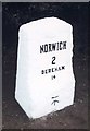
Old Milestone by the A1074, Dereham Road, Norwich parish
Metal plate attached to stone post by the A1074, in parish of NORWICH (NORWICH District), 90m West of junction with Marlpit Lane, 20m East of Tollhouse Cottage, behind metal railing at rear of pavement, on North side of road. Joseph Stanley iron plate (remade), originally erected by the Norwich & Swaffham turnpike trust in the 19th century.
Inscription reads:-
NORWICH
2
DEREHAM
14
Carved benchmark on lower mid front.
Norfolk HER.
NHER Number: 56386 https://www.heritagegateway.org.uk/Gateway/Results_Single.aspx?uid=MNF62792&resourceID=1002
Milestone Society National ID: NO_NSM02.
Image: © CW Haines
Taken: 18 Feb 2003
0.08 miles
6
Sign for Gristock Place, Hellesdon
Named after one of the five men of the Norfolk Regiment who were awarded the Victoria Cross. https://www.geograph.org.uk/photo/6318031
In total, six members of the Norfolk or Royal Norfolk Regiment were awarded the Victoria Cross the highest number for any one regiment.
Image: © Adrian S Pye
Taken: 8 Nov 2019
0.09 miles
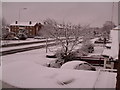
7
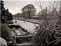
Snow, looking west along Dereham Road, Norwich
The large beech tree to the middle of the upper half of the photo has since been removed (July 2008) by the local council
Image: © Julie Bygrave
Taken: 24 Mar 2008
0.13 miles
8
Sign for Bates Green, Hellesdon
Named after one of the five men of the Norfolk Regiment who were awarded the Victoria Cross. https://www.geograph.org.uk/photo/6318031
In total, six members of the Norfolk or Royal Norfolk Regiment were awarded the Victoria Cross the highest number for any one regiment.
Image: © Adrian S Pye
Taken: 8 Nov 2019
0.14 miles