IMAGES TAKEN NEAR TO
Achilles Drive, NORWICH, NR5 0TU
Introduction
This page details the photographs taken nearby to Achilles Drive, NR5 0TU by members of the Geograph project.
The Geograph project started in 2005 with the aim of publishing, organising and preserving representative images for every square kilometre of Great Britain, Ireland and the Isle of Man.

There are currently over 7.5m images from over14,400 individuals and you can help contribute to the project by visiting https://www.geograph.org.uk
Image Map
Images are licensed for reuse under creativecommons.org/licenses/by-sa/2.0
Notes
- Clicking on the map will re-center to the selected point.
- The higher the marker number, the further away the image location is from the centre of the postcode.
Image Listing (6 Images Found)
Images are licensed for reuse under creativecommons.org/licenses/by-sa/2.0
Image
Details
Distance
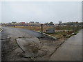
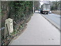
3
Costessey Park & Ride bus terminal
The site has 1100 parking spaces and bus services to Norwich via the University of East Anglia and to the Norfolk and Norwich University Hospital.
Image: © Graham Hogg
Taken: 23 Jul 2002
0.21 miles
4
Old Milestone
Old milestone on what was part of the A47 at Bawburgh, Norfolk. For overall view see http://www.geograph.org.uk/photo/1178894
Image: © Keith Evans
Taken: 25 Feb 2009
0.21 miles
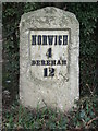
5
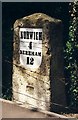
Old Milestone by the A1074, Dereham Road, Costessey parish
Metal plate attached to stone post by the A1074, in parish of COSTESSEY (SOUTH NORFOLK District), 10m East of drive to Lodge Farm, back of pavement/cycle track, behind wire fence at edge of wood (Turnpike Belts), on North side of road. Dereham iron plate, erected by the Norwich & Swaffham turnpike trust in the 19th century.
Inscription reads:-
NORWICH
4
DEREHAM
12
Carved benchmark on Lower right side.
Norfolk HER.
NHER Number: 56388 https://www.heritagegateway.org.uk/Gateway/Results_Single.aspx?uid=MNF62794&resourceID=1002
Milestone Society National ID: NO_NSM04.
Image: © CW Haines
Taken: 26 Mar 2002
0.23 miles
6
Norwich 3 Dereham 13
Old milestone on what was part of the A47 at Bawburgh, Norfolk. For close up view http://www.geograph.org.uk/photo/1178880
Image: © Keith Evans
Taken: 25 Feb 2009
0.24 miles