IMAGES TAKEN NEAR TO
Norwich Road, NORWICH, NR5 0LA
Introduction
This page details the photographs taken nearby to Norwich Road, NR5 0LA by members of the Geograph project.
The Geograph project started in 2005 with the aim of publishing, organising and preserving representative images for every square kilometre of Great Britain, Ireland and the Isle of Man.

There are currently over 7.5m images from over14,400 individuals and you can help contribute to the project by visiting https://www.geograph.org.uk
Image Map
Images are licensed for reuse under creativecommons.org/licenses/by-sa/2.0
Notes
- Clicking on the map will re-center to the selected point.
- The higher the marker number, the further away the image location is from the centre of the postcode.
Image Listing (4 Images Found)
Images are licensed for reuse under creativecommons.org/licenses/by-sa/2.0
Image
Details
Distance
1
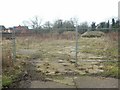
Site of Bridge Farm, Costessey
I believe this is the site of the farm (southwest of the bridge) - possibly soon to become a housing development like the area in the background.
Image: © Katy Walters
Taken: 11 Feb 2006
0.04 miles
2
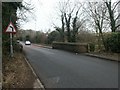
River Tud bridge, Costessey
On the road linking Old and New Costessey.
Image: © Katy Walters
Taken: 11 Feb 2006
0.08 miles
3
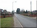
Norwich Road, Costessey
From the junction with Gunton Lane, Norwich-bound.
Image: © Katy Walters
Taken: 11 Feb 2006
0.22 miles
4
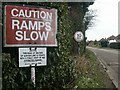
Gunton Lane, Costessey
A short part of this track is privately owned, but a right of way runs along it.
Image: © Katy Walters
Taken: 11 Feb 2006
0.22 miles