IMAGES TAKEN NEAR TO
Lamb Lane, NR4 7XS
Introduction
This page details the photographs taken nearby to Lamb Lane, NR4 7XS by members of the Geograph project.
The Geograph project started in 2005 with the aim of publishing, organising and preserving representative images for every square kilometre of Great Britain, Ireland and the Isle of Man.

There are currently over 7.5m images from over14,400 individuals and you can help contribute to the project by visiting https://www.geograph.org.uk
Image Map
Images are licensed for reuse under creativecommons.org/licenses/by-sa/2.0
Notes
- Clicking on the map will re-center to the selected point.
- The higher the marker number, the further away the image location is from the centre of the postcode.
Image Listing (27 Images Found)
Images are licensed for reuse under creativecommons.org/licenses/by-sa/2.0
Image
Details
Distance
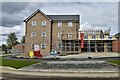
2
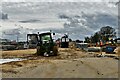
Cringleford: Work in progress on a huge housing estate
Image: © Michael Garlick
Taken: 11 Apr 2023
0.15 miles
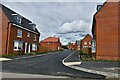
4
Cringleford: Housing street to be named though numbered
Image: © Michael Garlick
Taken: 11 Apr 2023
0.18 miles
5
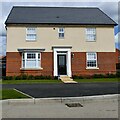
Cringleford: House under construction
Image: © Michael Garlick
Taken: 11 Apr 2023
0.20 miles
6
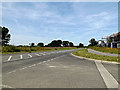
Round House Way, Cringleford
At the junction with Dragonfly Lane
Road No.C645
Image: © Geographer
Taken: 25 Jul 2014
0.20 miles
7
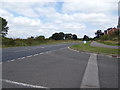
Round House Way, Cringleford
At the junction with Dragonfly Lane
Image: © Geographer
Taken: 4 Sep 2018
0.20 miles
8
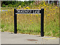
Dragonfly Lane sign
On Dragonfly Lane at the junction with Round House Way
Image: © Geographer
Taken: 25 Jul 2014
0.21 miles
9
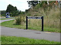
Dragonfly Lane sign
On Dragonfly Lane at the junction with Round House Way
Image: © Geographer
Taken: 4 Sep 2018
0.21 miles
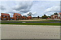
10
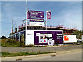
Care UK new care home
Off Round House Way at the junction with Dragonfly Lane
Image: © Geographer
Taken: 25 Jul 2014
0.21 miles