
IMAGES TAKEN NEAR TO
Queens Close, NORWICH, NR4 7PE
Introduction
This page details the photographs taken nearby to Queens Close, NR4 7PE by members of the Geograph project.
The Geograph project started in 2005 with the aim of publishing, organising and preserving representative images for every square kilometre of Great Britain, Ireland and the Isle of Man.

There are currently over 7.5m images from over14,400 individuals and you can help contribute to the project by visiting https://www.geograph.org.uk
Image Map
Images are licensed for reuse under creativecommons.org/licenses/by-sa/2.0
Notes
- Clicking on the map will re-center to the selected point.
- The higher the marker number, the further away the image location is from the centre of the postcode.
Image Listing (73 Images Found)
Images are licensed for reuse under creativecommons.org/licenses/by-sa/2.0
Image
Details
Distance
1

378 Unthank Road - The Children's Centre no more
Eaton Grange as seen from Upton Road. Although the signs are still in place, the centre closed in 2017, having been identified as surplus NHS land under the Naylor review, suggesting that the sale of the building could generate £2m for the NHS. Despite protests, its services were moved to the Norwich Community Hospital on Bowthorpe Road. The building had housed several community paediatric teams, including the children's key worker service, the ADHD psychology service, and a short break home nursing service.
In the late 1800s, this was the family home of Margaret Fountaine, known to some as the Norwich butterfly lady, who was an accomplished natural history illustrator, diarist and adventurer. The family moved to Eaton Grange in 1877, before she began travels around the world, which eventually resulted in a collection of 22,000 butterfly specimens (now housed at the Norwich Castle Museum).
After the family left, the building was a girls boarding school, before it became a centre for women with learning difficulties opened by the local authority in 1930.
Image: © Evelyn Simak
Taken: 10 Feb 2020
0.08 miles


4

The rear of a terrace on Unthank Road
As seen from Upton Road.
Image: © Evelyn Simak
Taken: 10 Feb 2020
0.11 miles

6

30 Leopold Road - The Beehive public house
By the junction with Melrose Road. The property was initially operated as a shop by Caroline Dixon since 1888 and licensed as a pub from August 1898. It has ever since been a public house and is still open today.
Image: © Evelyn Simak
Taken: 10 Feb 2020
0.12 miles
7
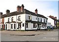
30 Leopold Road - The Beehive public house
By the junction with Melrose Road. The property was initially operated as a shop by Caroline Dixon since 1888 and licensed as a pub from August 1898. It has ever since been a public house and is still open today.
Image: © Evelyn Simak
Taken: 10 Feb 2020
0.12 miles
8

30 Leopold Road - The Beehive public house
By the junction with Melrose Road. The property was initially operated as a shop by Caroline Dixon since 1888 and licensed as a pub from August 1898. It has ever since been a public house and is still open today.
Image: © Evelyn Simak
Taken: 10 Feb 2020
0.12 miles
9

30 Leopold Road - The Beehive public house
By the junction with Melrose Road. The property was initially operated as a shop by Caroline Dixon since 1888 and licensed as a pub from August 1898. It has ever since been a public house and is still open today.
Image: © Evelyn Simak
Taken: 10 Feb 2020
0.12 miles
