IMAGES TAKEN NEAR TO
Intwood, NORWICH, NR4 6TG
Introduction
This page details the photographs taken nearby to NR4 6TG by members of the Geograph project.
The Geograph project started in 2005 with the aim of publishing, organising and preserving representative images for every square kilometre of Great Britain, Ireland and the Isle of Man.

There are currently over 7.5m images from over14,400 individuals and you can help contribute to the project by visiting https://www.geograph.org.uk
Image Map
Images are licensed for reuse under creativecommons.org/licenses/by-sa/2.0
Notes
- Clicking on the map will re-center to the selected point.
- The higher the marker number, the further away the image location is from the centre of the postcode.
Image Listing (66 Images Found)
Images are licensed for reuse under creativecommons.org/licenses/by-sa/2.0
Image
Details
Distance
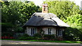
1
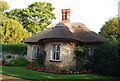
Lodge, Intwood Hall
Grade II listed. http://www.britishlistedbuildings.co.uk/en-226947-lodge-to-intwood-hall-circa-100-metres-n
Image: © N Chadwick
Taken: 30 Jun 2011
0.01 miles
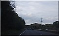
2
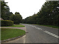
Intwood Road, Intwood
Looking towards the bridge over the A47 Norwich Southern Bypass near The Rectory
Road No.C178
Image: © Geographer
Taken: 11 Sep 2014
0.02 miles
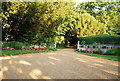
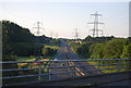
8
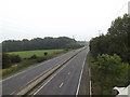
A47 Norwich Southern Bypass
Looking towards the B1113 Main Road off Intwood Road Bridge
Image: © Geographer
Taken: 11 Sep 2014
0.08 miles
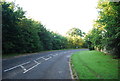
10
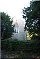
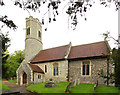
Church of All Saints, Intwood
Grade II* listed. http://www.britishlistedbuildings.co.uk/en-226946-church-of-all-saints-keswick-and-intwood
Image: © N Chadwick
Taken: 30 Jun 2011
0.10 miles