IMAGES TAKEN NEAR TO
Greenways, NORWICH, NR4 6HA
Introduction
This page details the photographs taken nearby to Greenways, NR4 6HA by members of the Geograph project.
The Geograph project started in 2005 with the aim of publishing, organising and preserving representative images for every square kilometre of Great Britain, Ireland and the Isle of Man.

There are currently over 7.5m images from over14,400 individuals and you can help contribute to the project by visiting https://www.geograph.org.uk
Image Map
Images are licensed for reuse under creativecommons.org/licenses/by-sa/2.0
Notes
- Clicking on the map will re-center to the selected point.
- The higher the marker number, the further away the image location is from the centre of the postcode.
Image Listing (12 Images Found)
Images are licensed for reuse under creativecommons.org/licenses/by-sa/2.0
Image
Details
Distance
1
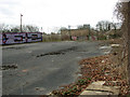
Abandoned recreation ground in Eaton, Norwich
This is part of the site of the former Civil Service Sports Ground which comprised several football pitches and a basketball court. The rubble in one corner originates from a demolished building, presumably changing rooms.
Image: © Evelyn Simak
Taken: 10 Mar 2011
0.15 miles
2
Abandoned recreation ground in Eaton, Norwich
See also > http://www.geograph.org.uk/photo/2303752. This is the site of the former Civil Service Sports Ground which comprised several football pitches and a basketball court. The rubble in one corner originates from a demolished building, presumably changing rooms.
Image: © Evelyn Simak
Taken: 10 Mar 2011
0.15 miles
3
Abandoned recreation ground in Eaton, Norwich
See also > http://www.geograph.org.uk/photo/2303752. This is the site of the former Civil Service Sports Ground which comprised several football pitches and a basketball court. The rubble in one corner originates from a demolished building, presumably changing rooms.
Image: © Evelyn Simak
Taken: 10 Mar 2011
0.15 miles
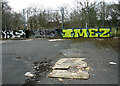
4

Graffiti in abandoned recreation ground in Eaton, Norwich
See also > http://www.geograph.org.uk/photo/2303752. This is the site of the former Civil Service Sports Ground which comprised several football pitches and a basketball court. The rubble in one corner originates from a demolished building, presumably changing rooms.
Image: © Evelyn Simak
Taken: 10 Mar 2011
0.15 miles
5
Abandoned recreation ground in Eaton, Norwich
See also > http://www.geograph.org.uk/photo/2303752. This is the site of the former Civil Service Sports Ground which comprised several football pitches and a basketball court. The rubble in one corner originates from a demolished building, presumably changing rooms.
Image: © Evelyn Simak
Taken: 10 Mar 2011
0.15 miles
6
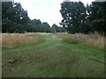
Eaton Golf Club
The course is split in two by Marston Lane - this image shows the middle of the main section.
Image: © Katy Walters
Taken: 16 Jul 2005
0.16 miles
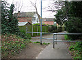
7
Footpath past new housing in Eaton, Norwich
Image: © Evelyn Simak
Taken: 10 Mar 2011
0.20 miles
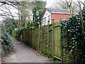
8
Footpath past small woodland in Eaton, Norwich
Image: © Evelyn Simak
Taken: 10 Mar 2011
0.20 miles
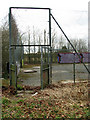
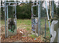
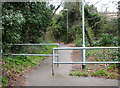
9
House behind high fence, Eaton (Norwich)
Image: © Evelyn Simak
Taken: 10 Mar 2011
0.21 miles
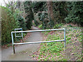
10
Footpath south of Newmarket Road, Eaton (Norwich)
Image: © Evelyn Simak
Taken: 10 Mar 2011
0.22 miles