IMAGES TAKEN NEAR TO
Dukesway, BUNGAY, NR35 2TR
Introduction
This page details the photographs taken nearby to Dukesway, NR35 2TR by members of the Geograph project.
The Geograph project started in 2005 with the aim of publishing, organising and preserving representative images for every square kilometre of Great Britain, Ireland and the Isle of Man.

There are currently over 7.5m images from over14,400 individuals and you can help contribute to the project by visiting https://www.geograph.org.uk
Image Map
Images are licensed for reuse under creativecommons.org/licenses/by-sa/2.0
Notes
- Clicking on the map will re-center to the selected point.
- The higher the marker number, the further away the image location is from the centre of the postcode.
Image Listing (104 Images Found)
Images are licensed for reuse under creativecommons.org/licenses/by-sa/2.0
Image
Details
Distance
1
The Queen's Head at Earsham, Norfolk
The Queen depicted on the sign is Queen Anne.
Image: © Adrian S Pye
Taken: 4 Dec 2010
0.03 miles
4
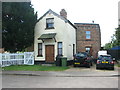
Earsham Railway station
The GER station is now a house. The white part hasn't changed but the brick part has lost the canopy and had windows added. I would have been on the track (this is now the bypass) looking onto the level crossing. The platform can be seen on the right.
It was on the Waveney Valley Railway running from Beccles to Tivetshall, it closed in the 1950s due to lack of use. The trackbed from Ditchingham to Wortwell is now the Bypass and was built in 1970.
http://www.bungay-suffolk.co.uk/history/reflections-9.htm
Image: © Ashley Dace
Taken: 6 Aug 2009
0.04 miles
5
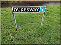
Dukes Way sign
On Dukes Way at the junction with Station Road
Image: © Geographer
Taken: 28 Feb 2014
0.04 miles
6
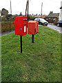
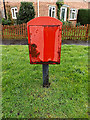
Dukes Way Postbox
On Dukes Way at the junction with Station Road
Postbox No.NR35 3539
Image: © Geographer
Taken: 28 Feb 2014
0.04 miles
7
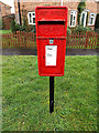
Dukes Way Postbox
On Dukes Way at the junction with Station Road
Postbox No.NR35 3539
Image: © Geographer
Taken: 28 Feb 2014
0.04 miles
8
Dukes Way Postbox
On Dukes Way at the junction with Station Road
Postbox No.NR35 3539
Image: © Geographer
Taken: 28 Feb 2014
0.04 miles
9
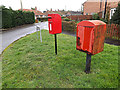
Royal Mail Dump Box
On Dukes Way at the junction with Station Road
(Close up)
Image: © Geographer
Taken: 28 Feb 2014
0.04 miles
10
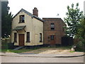
Earsham Railway station
A small building with one platform, the building has been extended (the part going into the 'sidings'). There was a level crossing and signal box.
The station was served by the Waveney Valley railway which ran from Beccles to Tivetshall. The trackbed is now occupied by the bypass which was built during the 1970s. As can be seen the station is now a house.
Image: © Ashley Dace
Taken: 6 Aug 2009
0.04 miles