IMAGES TAKEN NEAR TO
St. Johns Road, BUNGAY, NR35 1LP
Introduction
This page details the photographs taken nearby to St. Johns Road, NR35 1LP by members of the Geograph project.
The Geograph project started in 2005 with the aim of publishing, organising and preserving representative images for every square kilometre of Great Britain, Ireland and the Isle of Man.

There are currently over 7.5m images from over14,400 individuals and you can help contribute to the project by visiting https://www.geograph.org.uk
Image Map
Images are licensed for reuse under creativecommons.org/licenses/by-sa/2.0
Notes
- Clicking on the map will re-center to the selected point.
- The higher the marker number, the further away the image location is from the centre of the postcode.
Image Listing (111 Images Found)
Images are licensed for reuse under creativecommons.org/licenses/by-sa/2.0
Image
Details
Distance
1
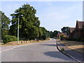
Old Grammar Lane, Bungay
Looking towards the B1062 Hillside Road West
Image: © Geographer
Taken: 22 Jul 2013
0.03 miles
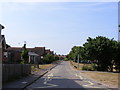
2
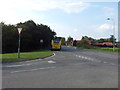
Junction of St John's Road & Hillside Road
Image: © Helen Steed
Taken: 24 Aug 2011
0.05 miles
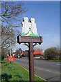
3
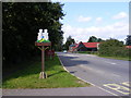
Bungay Town Sign
On the A144 St.John's Hill
Image: © Geographer
Taken: 29 Sep 2008
0.05 miles
4
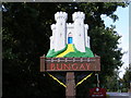
Bungay Town Sign
On the A144 St.John's Hill
(Close up)
Image: © Geographer
Taken: 29 Sep 2008
0.06 miles
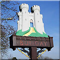
5
Bungay town sign
The sign shows Bungay Castles as it may have been in its heyday. Built by Roger Bigod of Norfolk, around 1100. Hugh Bigod, his son, went on to build a large square Norman keep on the site in 1165. During the Revolt of 1173–1174, Bungay was besieged, mined and ultimately destroyed by royal forces. The castle was restored to the Bigods and was further developed in 1294 by Roger Bigod, 5th Earl of Norfolk, who probably built the massive gate towers on the site as shown on the sign. Roger fell out of favour with King Edward I, and after Roger died the castle reverted to the Crown, falling into disrepair and ruin. The ruins are a magnet for visitors to the town.
In the spandrels a depiction of Black Shuck can be seen. During a thunderstorm (hence the lightning bolts) on the 4th August 1577 he broke through the doors, ran up the aisle, past a large congregation, killing a man and boy and causing the church steeple to collapse through the roof. So it is recorded.
Bungay Castle as it is now. https://www.geograph.org.uk/photo/1850271
https://www.geograph.org.uk/photo/6746584
Image: © Adrian S Pye
Taken: 12 Mar 2007
0.07 miles
6
Bungay town sign
The sign shows Bungay Castles as it may have been in its heyday. Built by Roger Bigod of Norfolk, around 1100. Hugh Bigod, his son, went on to build a large square Norman keep on the site in 1165. During the Revolt of 1173–1174, Bungay was besieged, mined and ultimately destroyed by royal forces. The castle was restored to the Bigods and was further developed in 1294 by Roger Bigod, 5th Earl of Norfolk, who probably built the massive gate towers on the site as shown on the sign. Roger fell out of favour with King Edward I, and after Roger died the castle reverted to the Crown, falling into disrepair and ruin. The ruins are a magnet for visitors to the town.
In the spandrels a depiction of Black Shuck can be seen. During a thunderstorm (hence the lightning bolts) on the 4th August 1577 he broke through the doors, ran up the aisle, past a large congregation, killing a man and boy and causing the church steeple to collapse through the roof. So it is recorded.
Bungay Castle as it is now. https://www.geograph.org.uk/photo/1850271
https://www.geograph.org.uk/photo/4291538
Image: © Adrian S Pye
Taken: 11 Dec 2020
0.07 miles
7
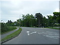
A144 St.John's Road, Bungay
At the junction with Hillside Road West
Image: © Geographer
Taken: 1 Jun 2013
0.07 miles
8
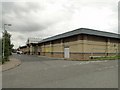
Swimming Pool at Bungay
The modern swimming pool is well attended by holiday makers and locals.
Image: © Adrian S Pye
Taken: 17 Aug 2010
0.08 miles
9
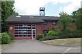
Bungay fire station
Bungay fire station, Hillside Road West, Bungay, Suffolk
Image: © Kevin Hale
Taken: 29 Jun 2010
0.08 miles
10
Old Grammar Lane, Bungay
Near the junction with the B1062 Hillside Road West
Image: © Geographer
Taken: 22 Jul 2013
0.09 miles