IMAGES TAKEN NEAR TO
Outney Meadow Caravan Park, BUNGAY, NR35 1HG
Introduction
This page details the photographs taken nearby to Outney Meadow Caravan Park, NR35 1HG by members of the Geograph project.
The Geograph project started in 2005 with the aim of publishing, organising and preserving representative images for every square kilometre of Great Britain, Ireland and the Isle of Man.

There are currently over 7.5m images from over14,400 individuals and you can help contribute to the project by visiting https://www.geograph.org.uk
Image Map
Images are licensed for reuse under creativecommons.org/licenses/by-sa/2.0
Notes
- Clicking on the map will re-center to the selected point.
- The higher the marker number, the further away the image location is from the centre of the postcode.
Image Listing (136 Images Found)
Images are licensed for reuse under creativecommons.org/licenses/by-sa/2.0
Image
Details
Distance
1
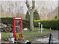
K8 Telephone box on Outney Common Caravan Park
Not sure whether or not it is still in use. They were first introduced in 1968 and are rare now.
Thanks to Stephen McKay for identifying it for me.
Image: © Adrian S Pye
Taken: 22 Jan 2011
0.01 miles
2
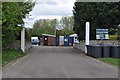
Waveney Valley Railway Crossing Gates
I presume the old crossing gates are from the old level crossing (now a roundabout) a few metres away. The Waveney Valley railway ran past here from Ditchingham to Bungay. Now they form the entrance to this caravan park.
See also Image]
Image: © Ashley Dace
Taken: 3 May 2010
0.01 miles
3
Old Level Crossing Gates at Bungay
I presume the old crossing gates are from the old level crossing (now a roundabout) a few metres away. The Waveney Valley railway ran past here from Ditchingham to Bungay see also.Image]
Plus this, to see how it would have been arranged Image]
Image: © Ashley Dace
Taken: 3 May 2010
0.03 miles
4
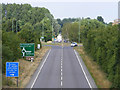
A143 at the junction with the A144 Broad Street
Image: © Geographer
Taken: 1 Jun 2013
0.05 miles
5

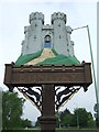
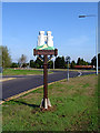
Bungay Name Sign
Bungay name sign at Bungay, Suffolk. For close up view see http://www.geograph.org.uk/photo/3963787
Image: © Keith Evans
Taken: 1 May 2014
0.05 miles
6
Bungay Town Name Sign
Bungay town name sign at Bungay, Suffolk for overall view see http://www.geograph.org.uk/photo/3963784
Image: © Keith Evans
Taken: 1 May 2014
0.05 miles
7
A143 at the junction with the A144 Broad Street
Image: © Geographer
Taken: 1 Jun 2013
0.05 miles
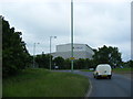
8
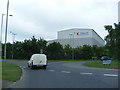
The A143 and A144 junction
At the junction of the A143 and the A144 is a roundabout, which has another exit to the left - leading to the golf course, Outney Common, and a caravan and camping site. The A143 is following the course of the old railway, which it continues to do beyond the roundabout.
Image: © Glen Denny
Taken: 25 Jul 2010
0.06 miles
9
Bungay Village Sign
The village sign on the main A143 road.
Image: © Linda Bailey
Taken: 16 Aug 2006
0.06 miles
10
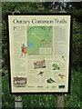
Outney Common Information Board
Information board on Outney common at Bungay, Suffolk.
Image: © Keith Evans
Taken: 1 May 2014
0.06 miles