
IMAGES TAKEN NEAR TO
Broad Street, BUNGAY, NR35 1EN
Introduction
This page details the photographs taken nearby to Broad Street, NR35 1EN by members of the Geograph project.
The Geograph project started in 2005 with the aim of publishing, organising and preserving representative images for every square kilometre of Great Britain, Ireland and the Isle of Man.

There are currently over 7.5m images from over14,400 individuals and you can help contribute to the project by visiting https://www.geograph.org.uk
Image Map
Images are licensed for reuse under creativecommons.org/licenses/by-sa/2.0
Notes
- Clicking on the map will re-center to the selected point.
- The higher the marker number, the further away the image location is from the centre of the postcode.
Image Listing (661 Images Found)
Images are licensed for reuse under creativecommons.org/licenses/by-sa/2.0
Image
Details
Distance
1

Brandy Lane
This information panel can be found on one of the walls of the alley and offers some explanation as to where the alley got its name from.
Image: © Glen Denny
Taken: 25 Jul 2010
0.01 miles
2

Bungay from Above
Viewed from St Mary's church tower. The white building in the centre is the Three Tuns, a restaurant and pub that closed in 2008. It has now reopened by the looks of it. I know it is extremely haunted as the banqueting hall is medieval in date, possibly linking with the castle. However the above ground part is recent, the original burning to the ground in 1688. Behind is the Barclays bank (the tall grey-fronted building) that may have been the site of the armoury.
Image: © Ashley Dace
Taken: 18 Jul 2010
0.01 miles
3
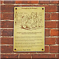
Smuggling in Bungay, heritage plaque in Brandy Lane
One of a series of 16 street plaques providing historic information about Bungay have been put up around the town as part of a new project to help residents and visitors learn more about Bungay’s history, heritage and buildings. https://www.geograph.org.uk/photo/7552999
Sponsored by Bungay Museum which is only open at weekends and Thursdays.
Image: © Adrian S Pye
Taken: 28 Jul 2023
0.01 miles
4

Brandy Lane, Bungay
Brandy Lane is a short-cut between Broad Street and Nethergate Street. The shop (No. 18) was once a Wine Merchants Image
Image: © Adrian S Pye
Taken: 4 May 2023
0.01 miles
5

Bungay Museum and Town Council Offices, Broad Street
The museum is open Weekends and Thursdays.
The Council offices Monday to Thursday 10am 'til 1 pm.
Image: © Adrian S Pye
Taken: 30 Jul 2023
0.02 miles
6

Brandy Lane
Brandy Lane is a pedestrian alley between Broad Street and Nethergate Street and is on a constant slope due to the difference in height between the two streets.
Image: © Glen Denny
Taken: 25 Jul 2010
0.02 miles
8

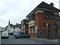
Nethergate Street
Other than at either of its ends Nethergate Street is residential, with a mixture of old and new houses.
Image: © Glen Denny
Taken: 25 Jul 2010
0.02 miles
9

Brandy Lane
Brandy Lane is a pedestrian alley leading from Broad Street to Nethergate Street. This is the sign at the Broad Street end of the alley and is appropriately situated on a now closed off licence!
Image: © Glen Denny
Taken: 25 Jul 2010
0.02 miles
10

Broad Street
This row of buildings occupies the north-eastern side of Broad Street and the part-timbered building nearest the camera is an antiques shop. Beyond this the majority of the buildings are used for residential purposes.
Image: © Glen Denny
Taken: 25 Jul 2010
0.03 miles