IMAGES TAKEN NEAR TO
Bardolph Road, BUNGAY, NR35 1BN
Introduction
This page details the photographs taken nearby to Bardolph Road, NR35 1BN by members of the Geograph project.
The Geograph project started in 2005 with the aim of publishing, organising and preserving representative images for every square kilometre of Great Britain, Ireland and the Isle of Man.

There are currently over 7.5m images from over14,400 individuals and you can help contribute to the project by visiting https://www.geograph.org.uk
Image Map
Images are licensed for reuse under creativecommons.org/licenses/by-sa/2.0
Notes
- Clicking on the map will re-center to the selected point.
- The higher the marker number, the further away the image location is from the centre of the postcode.
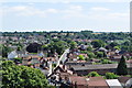
Image Listing (125 Images Found)
Images are licensed for reuse under creativecommons.org/licenses/by-sa/2.0
Image
Details
Distance
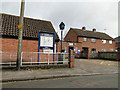
1
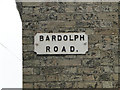
Bardolph Road, Bungay; Peace Year commemoration street sign
One of the 30 plus street signs commemorating the peace in 1919. Of the identical shape and size it, like Staithe Road does not bear the 1919 date.
Image: © Adrian S Pye
Taken: 15 Apr 2016
0.02 miles
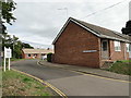
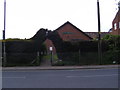
2

The old 'British Oak' public house, Bardolph Rd. Bungay
Converted into a private residence.
Image: © Adrian S Pye
Taken: 7 Aug 2017
0.03 miles
3
Honey Pot Meadow, Bungay
There seems to be an alternative spelling Honeypot or Honey Pot depending on which entrance you decide to use.
Image: © Adrian S Pye
Taken: 7 Aug 2017
0.03 miles
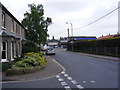
4
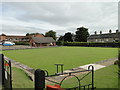
Bungay bowling green
Bardolph Road, Bungay
Image: © Adrian S Pye
Taken: 7 Aug 2017
0.04 miles
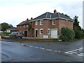
5
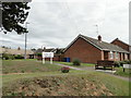
Honeypot Meadow, Bungay
Once the site of the local Social Security offices and later the Bungay Police Station. Now all residential.
Image: © Adrian S Pye
Taken: 7 Aug 2017
0.04 miles
7
The BBC at Bungay
Bungay Bowls Club
Off the A144 Lower Olland Street & St.John's Road at the junction with Wingfield Street
Image: © Geographer
Taken: 20 May 2013
0.06 miles
8
A144 St.John's Road, Bungay
At the junction with Wingfield Street
Image: © Geographer
Taken: 20 May 2013
0.06 miles
10
Bungay Street
The old mill in black is visible along the street, http://en.wikipedia.org/wiki/Flixton_Road_Mill,_Bungay.
This is the view of Upper Olland Street/Flixton Road in Bungay, which is the B road which leads to the southern part of Bungay before heading towards Flixton.
Image: © Ashley Dace
Taken: 18 Jul 2010
0.07 miles