
IMAGES TAKEN NEAR TO
Norfolk Road, BECCLES, NR34 8RE
Introduction
This page details the photographs taken nearby to Norfolk Road, NR34 8RE by members of the Geograph project.
The Geograph project started in 2005 with the aim of publishing, organising and preserving representative images for every square kilometre of Great Britain, Ireland and the Isle of Man.

There are currently over 7.5m images from over14,400 individuals and you can help contribute to the project by visiting https://www.geograph.org.uk
Image Map
Images are licensed for reuse under creativecommons.org/licenses/by-sa/2.0
Notes
- Clicking on the map will re-center to the selected point.
- The higher the marker number, the further away the image location is from the centre of the postcode.
Image Listing (159 Images Found)
Images are licensed for reuse under creativecommons.org/licenses/by-sa/2.0
Image
Details
Distance
1
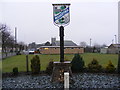
Wangford Village Sign
Off the B1126 Norfolk Road at the junction with Millfields
Image: © Geographer
Taken: 28 Jan 2009
0.02 miles
2
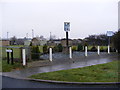
Wangford Village Sign
Off the B1126 Norfolk Road at the junction with Millfields
Image: © Geographer
Taken: 28 Jan 2009
0.02 miles
3
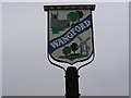
Wangford Village Sign
Off the B1126 Norfolk Road at the junction with Millfields
(Close up)
Image: © Geographer
Taken: 28 Jan 2009
0.02 miles
4
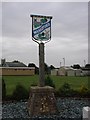
Wangford village sign
The sign depicts the church of St Peter above the name and the old smock mill which stood not 100 yards from this sign until it burnt down in August 1928. The area where it stood has been named Millfields. The wavy blue line containing the name relates to the River Wang, from which the parish takes its name. At the top of the sign is a blue and gold pattern; I did enquire as to what it represented but nobody in the village knew. https://www.geograph.org.uk/photo/6783580
Image: © Adrian S Pye
Taken: 22 Aug 2008
0.02 miles
5
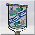
Wangford St Peter village sign
The sign depicts the church of St Peter above the name and the old smock mill which stood not 100 yards from this sign until it burnt down in August 1928. The area where it stood has been named Millfields. The wavy blue line containing the name relates to the River Wang, from which the parish takes its name. At the top of the sign is a blue and gold pattern; I did enquire as to what it represented but nobody in the village knew. https://www.geograph.org.uk/photo/4295687
Image: © Adrian S Pye
Taken: 16 Dec 2020
0.02 miles
6

B1126 Norfolk Road, Wangford
Looking towards Reydon at the junction with Millfields
Image: © Geographer
Taken: 28 Jan 2009
0.02 miles
7

Norfolk Road (B1126), Wangford
Looking north.
Image: © JThomas
Taken: 11 Oct 2016
0.02 miles

9
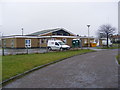
Wangford Community Centre
Off Millfields
Image: © Geographer
Taken: 28 Jan 2009
0.06 miles
