IMAGES TAKEN NEAR TO
Stoven, BECCLES, NR34 8ER
Introduction
This page details the photographs taken nearby to NR34 8ER by members of the Geograph project.
The Geograph project started in 2005 with the aim of publishing, organising and preserving representative images for every square kilometre of Great Britain, Ireland and the Isle of Man.

There are currently over 7.5m images from over14,400 individuals and you can help contribute to the project by visiting https://www.geograph.org.uk
Image Map
Images are licensed for reuse under creativecommons.org/licenses/by-sa/2.0
Notes
- Clicking on the map will re-center to the selected point.
- The higher the marker number, the further away the image location is from the centre of the postcode.
Image Listing (80 Images Found)
Images are licensed for reuse under creativecommons.org/licenses/by-sa/2.0
Image
Details
Distance
1
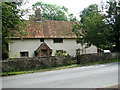
Traditional cottage beside St Margaret's church, Stoven
Image: © Evelyn Simak
Taken: 30 Jun 2011
0.01 miles

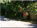
3
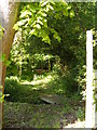
Footpath off Southwold Road
Near Stoven Church
Image: © Geographer
Taken: 27 May 2013
0.01 miles
4
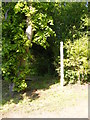
Footpath off Southwold Road
Near Stoven Church
Image: © Geographer
Taken: 27 May 2013
0.01 miles
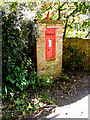
5
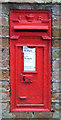
Close up, Victorian postbox, Stoven
Postbox No. NR34 3452.
See Image] for wider view.
Image: © JThomas
Taken: 13 Oct 2016
0.02 miles
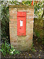
6
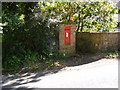
The Church Victorian Postbox
On Southwold Road
Postbox No.NR34 3452
Image: © Geographer
Taken: 27 May 2013
0.02 miles
7
The Church Victorian Postbox
On Wangford Road
Postbox No.NR34 3452
Image: © Geographer
Taken: 27 May 2013
0.02 miles
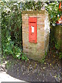
8
The Church Victorian Postbox
On Southwold Road
Postbox No.NR34 3452
Image: © Geographer
Taken: 27 May 2013
0.02 miles
9
The Church Victorian Postbox
On Southwold Road
Postbox No.NR34 3452
Image: © Geographer
Taken: 27 May 2013
0.02 miles
10
The Church Victorian Postbox
On Southwold Road
Postbox No.NR34 3452
Image: © Geographer
Taken: 27 May 2013
0.02 miles