IMAGES TAKEN NEAR TO
Mill Road, BECCLES, NR34 7UR
Introduction
This page details the photographs taken nearby to Mill Road, NR34 7UR by members of the Geograph project.
The Geograph project started in 2005 with the aim of publishing, organising and preserving representative images for every square kilometre of Great Britain, Ireland and the Isle of Man.

There are currently over 7.5m images from over14,400 individuals and you can help contribute to the project by visiting https://www.geograph.org.uk
Image Map
Images are licensed for reuse under creativecommons.org/licenses/by-sa/2.0
Notes
- Clicking on the map will re-center to the selected point.
- The higher the marker number, the further away the image location is from the centre of the postcode.
Image Listing (89 Images Found)
Images are licensed for reuse under creativecommons.org/licenses/by-sa/2.0
Image
Details
Distance
2
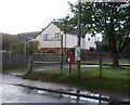
George VI postbox on Mill Road, Mutford
Postbox No. NR34 3443.
Image: © JThomas
Taken: 10 Oct 2016
0.01 miles
3
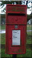
Close up, George VI postbox on Mill Road, Mutford
Postbox No. NR34 3443.
Image: © JThomas
Taken: 10 Oct 2016
0.01 miles
4

Mill Road & Mill Road George VI Postbox
Postbox No.NR34 3443
Image: © Geographer
Taken: 16 May 2014
0.02 miles
5

Mill Road George VI Postbox
On Mill Road
Postbox No.NR34 3443
Image: © Geographer
Taken: 16 May 2014
0.02 miles
6

Mill Road George VI Postbox
On Mill Road
Postbox No.NR34 3443
Image: © Geographer
Taken: 16 May 2014
0.02 miles
7
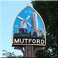
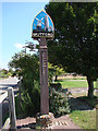
Mutford village sign
As well as the windmill which used to stand in Mill Road and the round tower church of St Andrew, the spandrels are formed by two fish representing the large number of men who went to sea on the boats out of Lowestoft. On the post itself is carved a wheatsheaf and below that set into the post is a copy of a thatcher’s comb representing just one of the many tradesmen, who at one time lived and worked in the parish. https://www.geograph.org.uk/photo/4293477
Image: © Adrian S Pye
Taken: 12 Dec 2020
0.02 miles
8
Mutford village sign
As well as the windmill which used to stand in Mill Road and the round tower church of St Andrew, the spandrels are formed by two fish representing the large number of men who went to sea on the boats out of Lowestoft. On the post itself is carved a wheatsheaf and below that set into the post is a copy of a thatcher’s comb representing just one of the many tradesmen, who at one time lived and worked in the parish. https://www.geograph.org.uk/photo/6779926
Image: © Adrian S Pye
Taken: 4 Oct 2013
0.02 miles
9
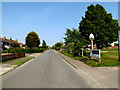
Mill Road & Mutford Village sign
Near Mutford Village Hall
Image: © Geographer
Taken: 16 May 2014
0.02 miles
10
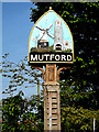
Mutford Village sign
Off Mill Road near Mutford Village Hall
(Close up)
Image: © Geographer
Taken: 16 May 2014
0.02 miles