IMAGES TAKEN NEAR TO
Church Lane, BECCLES, NR34 0DD
Introduction
This page details the photographs taken nearby to Church Lane, NR34 0DD by members of the Geograph project.
The Geograph project started in 2005 with the aim of publishing, organising and preserving representative images for every square kilometre of Great Britain, Ireland and the Isle of Man.

There are currently over 7.5m images from over14,400 individuals and you can help contribute to the project by visiting https://www.geograph.org.uk
Image Map
Images are licensed for reuse under creativecommons.org/licenses/by-sa/2.0
Notes
- Clicking on the map will re-center to the selected point.
- The higher the marker number, the further away the image location is from the centre of the postcode.
Image Listing (95 Images Found)
Images are licensed for reuse under creativecommons.org/licenses/by-sa/2.0
Image
Details
Distance
1
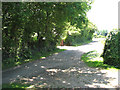
Track to St Mary's church
See > http://www.geograph.org.uk/photo/1337060 for a view of the church
Image: © Evelyn Simak
Taken: 2 Jun 2009
0.02 miles
2
St Mary, Burgh St Peter, Norfolk - East end
Image: © John Salmon
Taken: 15 Jul 2009
0.03 miles
3
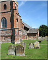
St Mary's church - churchyard
The southern section of St Mary's churchyard. For a view of the church see > http://www.geograph.org.uk/photo/1337060 .
Image: © Evelyn Simak
Taken: 2 Jun 2009
0.03 miles
4
St Mary's church - view east
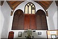
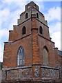
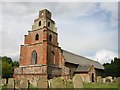
St Mary's church > http://www.geograph.org.uk/photo/1337060 - which at some time in the past was dedicated to St Peter - is situated about 2 kilometres from the centre of Burgh St Peter village, on the edge of Burgh Marshes > http://www.geograph.org.uk/photo/1337013. All traces of a chapel that once adjoined it have disappeared. The church is believed to stand on an ancient site which has been used as a place of worship for at least 1000 years. The unusual pagoda-style tower > http://www.geograph.org.uk/photo/1337079 serves as a mausoleum to members of the Boycott family, many of whom are buried in the sealed brick vaults at its base storey. Interestingly, the involvement of one of the Boycotts - Charles Cunningham Boycott (1832-1897) in the Irish 'troubles' in the mid 19th century resulted in the introduction to the English language of the word 'boycott'. Another unusual feature of this church is its great length > http://www.geograph.org.uk/photo/1337107 which is further enhanced by chancel and nave being of the same height. The thatched roof dates from the 15th century but was restored after a fire in 1998. The north and south doorways date to around 1200. The octagonal font > http://www.geograph.org.uk/photo/1337122 is C14 but both pulpit and rood screen > http://www.geograph.org.uk/photo/1337098 are more recent. This church is open every day.
Image: © Evelyn Simak
Taken: 2 Jun 2009
0.03 miles
5
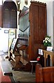
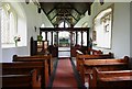
St Mary, Burgh St Peter, Norfolk - Organ
Image: © John Salmon
Taken: 15 Jul 2009
0.03 miles
6
St Mary's church
St Mary's church > http://www.geograph.org.uk/photo/1337060 - which at some time in the past was dedicated to St Peter - is situated about 2 kilometres from the centre of Burgh St Peter village, on the edge of Burgh Marshes > http://www.geograph.org.uk/photo/1337013. All traces of a chapel that once adjoined it have disappeared. The church is believed to stand on an ancient site which has been used as a place of worship for at least 1000 years. The unusual pagoda-style tower > http://www.geograph.org.uk/photo/1337079 serves as a mausoleum to members of the Boycott family, many of whom are buried in the sealed brick vaults at its base storey. Interestingly, the involvement of one of the Boycotts - Charles Cunningham Boycott (1832-1897) in the Irish 'troubles' in the mid 19th century resulted in the introduction to the English language of the word 'boycott'. Another unusual feature of this church is its great length > http://www.geograph.org.uk/photo/1337088 - http://www.geograph.org.uk/photo/1337107 which is further enhanced by chancel and nave being of the same height. The thatched roof dates from the 15th century but was restored after a fire in 1998. The north and south doorways date to around 1200. The octagonal font > http://www.geograph.org.uk/photo/1337122 is C14 but both pulpit and rood screen > http://www.geograph.org.uk/photo/1337098 are more recent.
Image: © Evelyn Simak
Taken: 2 Jun 2009
0.04 miles
7
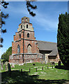
St Mary, western view
This view shows the unusual stepped brick west tower built around 1800.
This is a listed building id: 1304545 http://list.english-heritage.org.uk/resultsingle.aspx?uid=1304545 . Parish church. Fabric mainly early C14 with C16 tower base and nave roof.
Entry on Norfolk Churches website: http://www.norfolkchurches.co.uk/burghstpeter/burghstpeter.htm
Image: © Roger Jones
Taken: 13 Jul 2012
0.04 miles
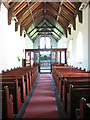
8
St Mary, Burgh St Peter, Norfolk - Decalogue
Image: © John Salmon
Taken: 15 Jul 2009
0.04 miles
9
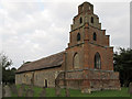
Church of St Mary, Burgh St Peter
By the 18th century the original tower was in ruins so a local family, the Boycotts, had their own stepped tower built onto the base in order that the church also became their family mausoleum. It is the Boycott family who gave the word boycott to the English language after a member of the family became shunned by everyone following an attempt to enforce rent rises in Ireland.
Image: © Glen Denny
Taken: 9 Sep 2007
0.04 miles
10
Parish Church of St Mary the Virgin, Burgh St Peter
The brick section was built in 1793 and intended as a mausoleum for Rev Samuel Boycott. The remainder of the church is 14th century. Many interesting features.
Image: © Roy Douglas
Taken: Unknown
0.04 miles