IMAGES TAKEN NEAR TO
Hornbeam Close, LOWESTOFT, NR33 9GD
Introduction
This page details the photographs taken nearby to Hornbeam Close, NR33 9GD by members of the Geograph project.
The Geograph project started in 2005 with the aim of publishing, organising and preserving representative images for every square kilometre of Great Britain, Ireland and the Isle of Man.

There are currently over 7.5m images from over14,400 individuals and you can help contribute to the project by visiting https://www.geograph.org.uk
Image Map
Images are licensed for reuse under creativecommons.org/licenses/by-sa/2.0
Notes
- Clicking on the map will re-center to the selected point.
- The higher the marker number, the further away the image location is from the centre of the postcode.
Image Listing (6 Images Found)
Images are licensed for reuse under creativecommons.org/licenses/by-sa/2.0
Image
Details
Distance
1
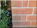
Bench mark on 269 Long Road
This cut mark is on the north side of the house and faces NNE and is approximately 60cms above ground level. To view the house > http://www.geograph.org.uk/photo/2075050 For more information on this and other bench marks visit the bench mark database > http://www.bench-marks.org.uk/bm35590
Image: © Adrian S Pye
Taken: 20 Sep 2010
0.11 miles
2
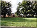
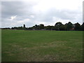
Houses in a tree-lined road
These houses are fronted by a green and trees planted along the side of Long Road, Lowestoft.
Image: © Adrian S Pye
Taken: 20 Sep 2010
0.11 miles
3
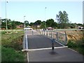
Cycleway and Pedestrian Footbridge
Leading to new road, Lowestoft
Image: © Ian Robertson
Taken: 18 May 2007
0.17 miles
4
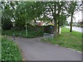
Start of Cycleway to New Road
Between Kirkley and Carlton Colville
Image: © Ian Robertson
Taken: 18 May 2007
0.18 miles
5
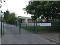
Whitton Green Community Primary School
Image: © Ian Robertson
Taken: 18 May 2007
0.22 miles