
IMAGES TAKEN NEAR TO
Beverley Close, LOWESTOFT, NR33 8QQ
Introduction
This page details the photographs taken nearby to Beverley Close, NR33 8QQ by members of the Geograph project.
The Geograph project started in 2005 with the aim of publishing, organising and preserving representative images for every square kilometre of Great Britain, Ireland and the Isle of Man.

There are currently over 7.5m images from over14,400 individuals and you can help contribute to the project by visiting https://www.geograph.org.uk
Image Map
Images are licensed for reuse under creativecommons.org/licenses/by-sa/2.0
Notes
- Clicking on the map will re-center to the selected point.
- The higher the marker number, the further away the image location is from the centre of the postcode.
Image Listing (19 Images Found)
Images are licensed for reuse under creativecommons.org/licenses/by-sa/2.0
Image
Details
Distance
1
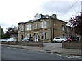
Care home on Cotmer Road
Showing position of Postbox No. NR33 3353.
See Image] for postbox.
Image: © JThomas
Taken: 13 Oct 2016
0.10 miles
2
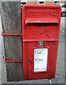
Elizabeth II postbox on Cotmer Road
Postbox No. NR33 3353.
See Image] for context.
Image: © JThomas
Taken: 13 Oct 2016
0.11 miles

4

Cotmer Road, Oulton Broad
Heading south east.
Image: © JThomas
Taken: 13 Oct 2016
0.15 miles
5
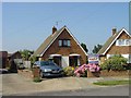
Houses in Residential Area of Oulton Broad, Lowestoft, Suffolk
This grid square is mainly residential. Most of the housing was built in batches on estates of various ages. The photo shows a typical three bedroom house built in the early 1960s in a chalet bungalow style.
Image: © Pete Chapman
Taken: 8 Aug 2004
0.16 miles
6

Residential housing estate, Oulton Broad, Lowestoft, Suffolk
Conrad Close is part of an estate of 1960s houses, a mixture of semi-detached bungalows and two storey houses. View taken looking SE towards the rising winter sun.
Image: © Pete Chapman
Taken: Unknown
0.16 miles
7
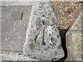
Pivot bench mark on a milestone.
This milestone is at TM 5173092026 and has a pivot bench mark and rivet on the top. For a full view click > http://www.geograph.org.uk/photo/2001836 For more information on this and other bench marks visit the bench mark database > http://www.bench-marks.org.uk/bm35102
Image: © Adrian S Pye
Taken: 8 Aug 2010
0.21 miles
8
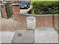
Milestone with pivot bench mark
The milestone stands beside the A146 1 mile nearer Lowestoft than > For a closer view of the mark click > http://www.geograph.org.uk/photo/2001831
Image: © Adrian S Pye
Taken: 8 Aug 2010
0.21 miles
9
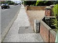
Milestone with pivot bench mark
The milestone is beside the A146 Beccles Road in Oulton Broad. To see the pivot mark click > http://www.geograph.org.uk/photo/2001831
Image: © Adrian S Pye
Taken: 8 Aug 2010
0.21 miles
10
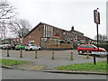
The 'King Alfred' public house
Burnt Hill Way, Lowestoft
Image: © Adrian S Pye
Taken: 12 Feb 2017
0.21 miles