IMAGES TAKEN NEAR TO
Francis Road, LOWESTOFT, NR33 7PU
Introduction
This page details the photographs taken nearby to Francis Road, NR33 7PU by members of the Geograph project.
The Geograph project started in 2005 with the aim of publishing, organising and preserving representative images for every square kilometre of Great Britain, Ireland and the Isle of Man.

There are currently over 7.5m images from over14,400 individuals and you can help contribute to the project by visiting https://www.geograph.org.uk
Image Map
Images are licensed for reuse under creativecommons.org/licenses/by-sa/2.0
Notes
- Clicking on the map will re-center to the selected point.
- The higher the marker number, the further away the image location is from the centre of the postcode.
Image Listing (9 Images Found)
Images are licensed for reuse under creativecommons.org/licenses/by-sa/2.0
Image
Details
Distance
1
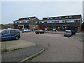
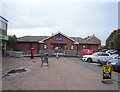
Shops by Field Lane, Kessingland
Image: © Hugh Venables
Taken: 14 Apr 2018
0.08 miles
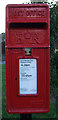
3
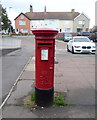
Elizabeth II postbox outside the Co-op, Kessingland
Image: © JThomas
Taken: 11 Oct 2016
0.08 miles
4
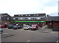
Co-operative food store, Kessingland
Showing position of Postbox No. NR33 3323.
See Image] for postbox.
Image: © JThomas
Taken: 11 Oct 2016
0.09 miles
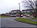
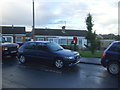
5
Surgery, Kessingland
Showing position of Postbox No. NR33 3323.
See Image] for postbox.
Image: © JThomas
Taken: 11 Oct 2016
0.09 miles
6
Close up, Elizabeth II postbox on Lloyds Avenue, Kessingland
Postbox No. NR33 3328.
See Image] for wider view.
Image: © JThomas
Taken: 10 Oct 2016
0.22 miles
7
Bungalows on Lloyds Avenue, Kessingland
Showing position of Postbox No. NR33 3328.
See Image] for postbox.
Image: © JThomas
Taken: 10 Oct 2016
0.22 miles
8
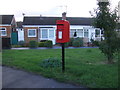
Elizabeth II postbox on Lloyds Avenue, Kessingland
Image: © JThomas
Taken: 10 Oct 2016
0.22 miles
9
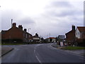
B1437 London Road
At the junction with Field Lane
Image: © Geographer
Taken: 1 Mar 2013
0.22 miles