
IMAGES TAKEN NEAR TO
Walmer Road, LOWESTOFT, NR33 7LA
Introduction
This page details the photographs taken nearby to Walmer Road, NR33 7LA by members of the Geograph project.
The Geograph project started in 2005 with the aim of publishing, organising and preserving representative images for every square kilometre of Great Britain, Ireland and the Isle of Man.

There are currently over 7.5m images from over14,400 individuals and you can help contribute to the project by visiting https://www.geograph.org.uk
Image Map
Images are licensed for reuse under creativecommons.org/licenses/by-sa/2.0
Notes
- Clicking on the map will re-center to the selected point.
- The higher the marker number, the further away the image location is from the centre of the postcode.
Image Listing (121 Images Found)
Images are licensed for reuse under creativecommons.org/licenses/by-sa/2.0
Image
Details
Distance
1
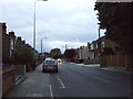
London Road South (B1532)
Looking south west.
Image: © JThomas
Taken: 12 Oct 2016
0.04 miles
3
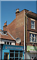
Lowestoft : ghost sign
"Simpsons for Footwear"
Image: © Jim Osley
Taken: 7 Jul 2019
0.09 miles
4
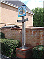
Pakefield village sign
The sign depicts the two churches on one. St Margaret’s in one side and All Saints in the other. It all started with a dispute between the Pye and Rothenhale families. Each wanted to build a church and so they did, on the same site, because that was where the Saxon tower stood, side by side. Each church had its own Rector, and its own congregation until 1411. It was then, that the rector of All Saints, Robert Graunt, became also Rector of St Margaret’s as well, and knocked through a doorway to unite both churches. During the following ten years, he pierced the dividing wall and inserted the pillars and arches, and constructed a rood screen the full width of the two churches. About the same time the new square tower was built. After Graunt’s death in 1421, the arches were filled in, and for the next 128 years each church again had its own Rector, and although after 1549 nearly every Rector was a “pluralist” for at least a part of his incumbency. It was not until 1748 that common sense prevailed, and the two churches were legally and permanently joined to become the Parish Church of All Saints and Saint Margaret.
The sun behind the church symbolises the Sunshine Coast, while the fish reflect the historical main industry, fishing. The beach and sea feature in the foreground.
Image: © Adrian S Pye
Taken: 18 Jun 2013
0.10 miles
5

Pakefield village sign
The sign depicts the two churches on one. St Margaret’s in one side and All Saints in the other. It all started with a dispute between the Pye and Rothenhale families. Each wanted to build a church and so they did, on the same site, because that was where the Saxon tower stood, side by side. Each church had its own Rector, and its own congregation until 1411. It was then, that the rector of All Saints, Robert Graunt, became also Rector of St Margaret’s as well, and knocked through a doorway to unite both churches. During the following ten years, he pierced the dividing wall and inserted the pillars and arches, and constructed a rood screen the full width of the two churches. About the same time the new square tower was built. After Graunt’s death in 1421, the arches were filled in, and for the next 128 years each church again had its own Rector, and although after 1549 nearly every Rector was a “pluralist” for at least a part of his incumbency. It was not until 1748 that common sense prevailed, and the two churches were legally and permanently joined to become the Parish Church of All Saints and Saint Margaret.
The sun behind the church symbolises the Sunshine Coast, while the fish reflect the historical main industry, fishing. The beach and sea feature in the foreground. https://www.geograph.org.uk/photo/4293739
Image: © Adrian S Pye
Taken: 21 Aug 2008
0.10 miles
6
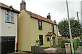
Olney Cottage, Pakefield
Olney Cottage is a grade II listed building. There is a plaque above the door stating that in the early 19th century it was moved from Pakefield cliffs, brick by brick and rebuilt on this spot. To view the plaque see >
https://www.geograph.org.uk/photo/2075302
Image: © Adrian S Pye
Taken: 15 Sep 2022
0.11 miles
7
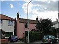
Olney Cottage, Pakefield Street
Olney Cottage is a listed building. There is a plaque on the wall stating that in the early 19th century it was moved from Pakefield cliffs, brick by brick and rebuilt on this spot. To view the plaque see > http://www.geograph.org.uk/photo/2075302
Image: © Adrian S Pye
Taken: 20 Sep 2010
0.11 miles
9
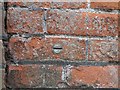
Bench mark bolt
This bench mark bolt is without its usual bar and arrow. But may be below it and to the left, (very faint). It is set into a wall just to the right of a house called Glen Manna in Pakefield Street, Pakefield at the junction with London Road, near the old Tram Terminus it faces NW and is approximately 50cms above the level of the pavement. GR. TM53610 90561. For more information on this and other bench marks visit the bench mark database > http://www.bench-marks.org.uk/bm35599
Image: © Adrian S Pye
Taken: 20 Sep 2010
0.11 miles
10

Pakefield Post Offcce
Showing position of Postbox No. NR33 3305.
Image: © JThomas
Taken: 13 Oct 2016
0.11 miles