IMAGES TAKEN NEAR TO
Magdalen Close, LOWESTOFT, NR32 4TP
Introduction
This page details the photographs taken nearby to Magdalen Close, NR32 4TP by members of the Geograph project.
The Geograph project started in 2005 with the aim of publishing, organising and preserving representative images for every square kilometre of Great Britain, Ireland and the Isle of Man.

There are currently over 7.5m images from over14,400 individuals and you can help contribute to the project by visiting https://www.geograph.org.uk
Image Map
Images are licensed for reuse under creativecommons.org/licenses/by-sa/2.0
Notes
- Clicking on the map will re-center to the selected point.
- The higher the marker number, the further away the image location is from the centre of the postcode.
Image Listing (16 Images Found)
Images are licensed for reuse under creativecommons.org/licenses/by-sa/2.0
Image
Details
Distance
2

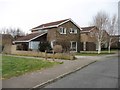
Site of a WW2 FW3/22 pillbox
The pillbox was placed to protect the stop-line which ran across College Farm and the nearby Anti-Aircraft emplacement a 150 yards ESE of the block-house.
Image: © Adrian S Pye
Taken: 2 Apr 2023
0.10 miles
3
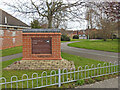
College Farm Estate history plaque
The plaque is on a purpose built brick plinth telling the history of the former farm and the acquisition of the land after it's role in World War Two. A plaque on the reverse outlines the WW2 role in the defence of Lowestoft and anti-invasion measures.
The plaque reads: "College Farm once owned by St. Mary Magdalene College, Oxford, stretched from Sharon Drive to Foxborough School. The Boggis family worked this arable and dairy farm. This area was known as the 'Church Fields', having a footpath linking Oulton Village to St. Margaret's Church.
The Farm was bought by the Warnes family in 1958 for housing development. This plaque was placed here on 28th June 2004 near the completion of the estate. The principle for the Warnes Family over the years has been these words from the Bible: 'In all your ways acknowledge Him (God) and He shall direct your paths.' Proverbs ch.3 v.6."
Image: © Adrian S Pye
Taken: 2 Apr 2023
0.13 miles
4
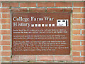
College Farm Estate history plaque (reverse)
This plaque on the reverse of Image] outlines the World War Two role College Farm played in the defence of Lowestoft and anti-invasion measures.
The site of the pillbox can be seen here Image
The Anti Aircraft Battery stood here Image
The graves of the Ju88 crew are in Lowestoft cemetery Image
There were also almost 5 miles of cube shaped tank traps, each consisting of at least 1.5 cubic yards of concrete, laid out, about 700 to the mile in around Lowestoft, Oulton Broad and Gunton creating a stop line
Image: © Adrian S Pye
Taken: 2 Apr 2023
0.13 miles
5
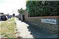
El Alamein Road, Lowestoft
Many of the roads hereabouts are named in remembrance of WW2 leaders and famous ships. El Alamein, Montgomery, Churchill, Mountbatten, Hollingsworth, Spashett, Teddar, Harris, RNPS Europa, HMS Mylodon, HMS Godetia, SS Hopelyn, Minos, Arnhem, Normandy. From WW1 Castleton, Crisp, Telesia.
Image: © Adrian S Pye
Taken: 10 Jul 2022
0.13 miles
6
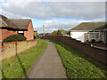
Path between Hilltop Green and Clovelly Rise
The site of a World War Two Heavy Anti-Aircraft gun emplacement. There were three guns and ammunition bunkers covering and area of roughly 3500 square metres. Almost identical to the one in Lound at TM 4989 9957
The College Farm information plaque can be seen here Image
Image: © Adrian S Pye
Taken: 2 Apr 2023
0.14 miles
7
Stench pipe #2 in Spashett Road, Lowestoft
Made by Adams Ltd. York
Image: © Adrian S Pye
Taken: 10 Jul 2022
0.14 miles
9
Stench pipe in Teddar Road, Lowestoft
Made By Adams Ltd. York
Image: © Adrian S Pye
Taken: 10 Jul 2022
0.17 miles
10
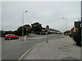
Woods Loke to the left, Oulton Road to the right
Junction near the Norman Warrior public house, looking west.
Image: © Adrian S Pye
Taken: 29 Oct 2010
0.17 miles