IMAGES TAKEN NEAR TO
Oulton Road, LOWESTOFT, NR32 4QS
Introduction
This page details the photographs taken nearby to Oulton Road, NR32 4QS by members of the Geograph project.
The Geograph project started in 2005 with the aim of publishing, organising and preserving representative images for every square kilometre of Great Britain, Ireland and the Isle of Man.

There are currently over 7.5m images from over14,400 individuals and you can help contribute to the project by visiting https://www.geograph.org.uk
Image Map
Images are licensed for reuse under creativecommons.org/licenses/by-sa/2.0
Notes
- Clicking on the map will re-center to the selected point.
- The higher the marker number, the further away the image location is from the centre of the postcode.
Image Listing (7 Images Found)
Images are licensed for reuse under creativecommons.org/licenses/by-sa/2.0
Image
Details
Distance
1
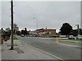
Parade of shops in Oulton Road, Lowestoft
Image: © Adrian S Pye
Taken: 29 Oct 2010
0.03 miles
3
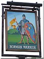
The Norman Warrior sign
The Norman Warrior Pub sign Fir Lane, Lowestoft, Suffolk.
Image: © Keith Evans
Taken: 1 Oct 2007
0.07 miles
4
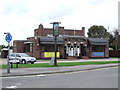
The Norman Warrior
The Norman Warrior public house, Fir Lane, Lowestoft, Suffolk.
Image: © Keith Evans
Taken: 1 Oct 2007
0.07 miles
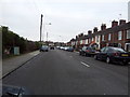
5
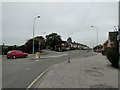
Woods Loke to the left, Oulton Road to the right
Junction near the Norman Warrior public house, looking west.
Image: © Adrian S Pye
Taken: 29 Oct 2010
0.09 miles
6
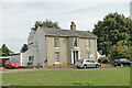
The Beeches, Lowestoft
The former early 19th century country house is grade II listed
Image: © Adrian S Pye
Taken: 22 Sep 2022
0.18 miles
7
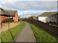
Path between Hilltop Green and Clovelly Rise
The site of a World War Two Heavy Anti-Aircraft gun emplacement. There were three guns and ammunition bunkers covering and area of roughly 3500 square metres. Almost identical to the one in Lound at TM 4989 9957
The College Farm information plaque can be seen here Image
Image: © Adrian S Pye
Taken: 2 Apr 2023
0.20 miles