IMAGES TAKEN NEAR TO
Melrose Close, LOWESTOFT, NR32 4QJ
Introduction
This page details the photographs taken nearby to Melrose Close, NR32 4QJ by members of the Geograph project.
The Geograph project started in 2005 with the aim of publishing, organising and preserving representative images for every square kilometre of Great Britain, Ireland and the Isle of Man.

There are currently over 7.5m images from over14,400 individuals and you can help contribute to the project by visiting https://www.geograph.org.uk
Image Map
Images are licensed for reuse under creativecommons.org/licenses/by-sa/2.0
Notes
- Clicking on the map will re-center to the selected point.
- The higher the marker number, the further away the image location is from the centre of the postcode.
Image Listing (35 Images Found)
Images are licensed for reuse under creativecommons.org/licenses/by-sa/2.0
Image
Details
Distance
1
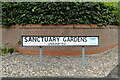
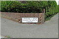
Sanctuary Gardens street sign
So named because the close is built within the grounds of an old church, now a private house and renamed Sanctuary House. https://www.geograph.org.uk/photo/7280499
Image: © Adrian S Pye
Taken: 12 Sep 2022
0.08 miles
2
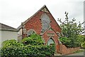
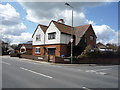
The former Primitive Methodist church, Oulton
The church was built in 1903 but is now a private dwelling house and renamed Sanctuary House.
Image: © Adrian S Pye
Taken: 12 Sep 2022
0.09 miles
3

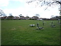
Playing Field and Health Clinic
Playing Field and Health Clinic at Oulton Village, north-west of Lowestoft.
Image: © Adrian S Pye
Taken: 21 Jul 2010
0.10 miles

8
Union Lane street sign
Union Lane lead to the old Mutford and Lothingland Union, otherwise known as The Workhouse, The Poor House or the House of Industry. Whatever it was called it was the last place anyone wanted to be.
It was built in 1765 at a cost of nearly £6,000 which included the governor's apartment, the chapel, mortuary and various offices. There were four large workrooms where the inmates treated hemp to make rope and sacks, spun wool for clothing and made fishing nets for the Lowestoft drifters.
In the late 1800s two infirmary blocks were added. However after 1930 it underwent a change of use and became an infirmary for the "mentally afflicted" and renamed The Lowestoft Hospital.
The original building was demolished in the 1960s leaving the two infirmary blocks only to be demolished 30 years later. For a while the remaining chapel was used as part of an ambulance station.
A care home was constructed on the site in which the conditions for the elderly are somewhat more pleasant.
Now nothing remains of the Union except the road name and a page of history https://www.workhouses.org.uk/Mutford/
Image: © Adrian S Pye
Taken: 12 Sep 2022
0.14 miles
10
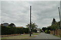
Stench pipe in Oulton Road North, Lowestoft
Part of the north west Lowestoft sewage system still at its full height with a wire balloon to prevent birds falling into the pipe.
Image: © Adrian S Pye
Taken: 12 Sep 2022
0.14 miles