IMAGES TAKEN NEAR TO
High Road, GREAT YARMOUTH, NR31 9QN
Introduction
This page details the photographs taken nearby to High Road, NR31 9QN by members of the Geograph project.
The Geograph project started in 2005 with the aim of publishing, organising and preserving representative images for every square kilometre of Great Britain, Ireland and the Isle of Man.

There are currently over 7.5m images from over14,400 individuals and you can help contribute to the project by visiting https://www.geograph.org.uk
Image Map
Images are licensed for reuse under creativecommons.org/licenses/by-sa/2.0
Notes
- Clicking on the map will re-center to the selected point.
- The higher the marker number, the further away the image location is from the centre of the postcode.
Image Listing (18 Images Found)
Images are licensed for reuse under creativecommons.org/licenses/by-sa/2.0
Image
Details
Distance
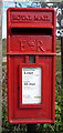
2
Elizabeth II postbox on Mill Road, Burgh Castle
Image: © JThomas
Taken: 28 Apr 2016
0.04 miles
3
Close up, Elizabeth II postbox on Mill Road, Burgh Castle
Postbox No. NR31 3147.
See Image] for wider view.
Image: © JThomas
Taken: 28 Apr 2016
0.04 miles
4
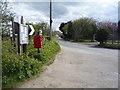
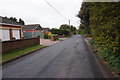
Mill Road, Burgh Castle
Looking south showing position of Postbox No. NR31 3147.
See Image] for postbox
Image: © JThomas
Taken: 28 Apr 2016
0.04 miles
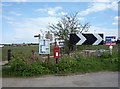
8
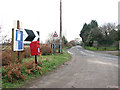
Postbox by corner of High Road/Mill Road
Image: © Evelyn Simak
Taken: 15 Jan 2010
0.08 miles