IMAGES TAKEN NEAR TO
NR31 9FW
Introduction
This page details the photographs taken nearby to NR31 9FW by members of the Geograph project.
The Geograph project started in 2005 with the aim of publishing, organising and preserving representative images for every square kilometre of Great Britain, Ireland and the Isle of Man.

There are currently over 7.5m images from over14,400 individuals and you can help contribute to the project by visiting https://www.geograph.org.uk
Image Map
Images are licensed for reuse under creativecommons.org/licenses/by-sa/2.0
Notes
- Clicking on the map will re-center to the selected point.
- The higher the marker number, the further away the image location is from the centre of the postcode.
Image Listing (18 Images Found)
Images are licensed for reuse under creativecommons.org/licenses/by-sa/2.0
Image
Details
Distance
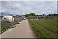
1
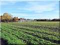
Electricity sub-station as seen across farmland
Image: © Helen Steed
Taken: 13 Nov 2012
0.04 miles
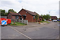
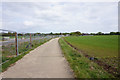
6
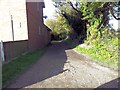
Start of the footpath known as Jews Lane, Bradwell
Image: © Helen Steed
Taken: 13 Nov 2012
0.11 miles
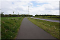
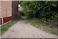
7
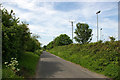
Woodfarm Lane - Gorleston
Woodfarm Lane, nearby is Gorleston Football Club.
Image: © Richard Robinson
Taken: 20 May 2007
0.12 miles