IMAGES TAKEN NEAR TO
Kingfisher Close, GREAT YARMOUTH, NR31 8PG
Introduction
This page details the photographs taken nearby to Kingfisher Close, NR31 8PG by members of the Geograph project.
The Geograph project started in 2005 with the aim of publishing, organising and preserving representative images for every square kilometre of Great Britain, Ireland and the Isle of Man.

There are currently over 7.5m images from over14,400 individuals and you can help contribute to the project by visiting https://www.geograph.org.uk
Image Map
Images are licensed for reuse under creativecommons.org/licenses/by-sa/2.0
Notes
- Clicking on the map will re-center to the selected point.
- The higher the marker number, the further away the image location is from the centre of the postcode.
Image Listing (12 Images Found)
Images are licensed for reuse under creativecommons.org/licenses/by-sa/2.0
Image
Details
Distance
1
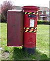
Elizabeth II postbox on Mill Lane
Postbox No. NR31 3137.
Image: © JThomas
Taken: 28 Apr 2016
0.10 miles
2
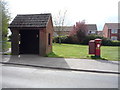
Elizabeth II postbox and bus shelter on Mill Lane
Image: © JThomas
Taken: 28 Apr 2016
0.10 miles
8
Mill Lane, Bradwell and street-name sign
Image: © Adrian S Pye
Taken: 19 Dec 2014
0.19 miles