
IMAGES TAKEN NEAR TO
Viking Close, GREAT YARMOUTH, NR31 6ES
Introduction
This page details the photographs taken nearby to Viking Close, NR31 6ES by members of the Geograph project.
The Geograph project started in 2005 with the aim of publishing, organising and preserving representative images for every square kilometre of Great Britain, Ireland and the Isle of Man.

There are currently over 7.5m images from over14,400 individuals and you can help contribute to the project by visiting https://www.geograph.org.uk
Image Map
Images are licensed for reuse under creativecommons.org/licenses/by-sa/2.0
Notes
- Clicking on the map will re-center to the selected point.
- The higher the marker number, the further away the image location is from the centre of the postcode.
Image Listing (41 Images Found)
Images are licensed for reuse under creativecommons.org/licenses/by-sa/2.0
Image
Details
Distance
1
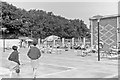
Swimming pool, Gorleston Holiday Camp, 1966
The corner of the sports hall is on the right. All traces of the holiday camp have now vanished under a housing estate.
Image: © C. P. Webster
Taken: Unknown
0.05 miles
2
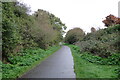
The footpath on the line of the track continues into town
At this point we are about 500 yards from Gorleston Station.
It was at the point where the path bends that there was a turnout for sidings and access to the goods shed which once stood a few yards southwest of the station buildings.
Image: © Adrian S Pye
Taken: 27 Oct 2022
0.05 miles
3
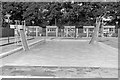
Swimming pool, Gorleston Holiday Camp, 1966
All traces of the holiday camp have now vanished under a housing estate.
Image: © C. P. Webster
Taken: Unknown
0.05 miles
4
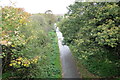
Looking north over the bridge parapet
The former route of the railway track is easily recognised.
Image: © Adrian S Pye
Taken: 27 Oct 2022
0.08 miles
5
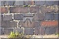
Bench Mark, Gorleston, Bridge Road
Cut bench mark on former railway bridge, Bridge Road, Gorleston.
CUT MARK: RLY BR BRIDGE RD 1.0M NW PARA BUTT (ODN 19.4828m AGL 0.2m)
Image: © Quovis
Taken: 2 Jan 2012
0.12 miles
6
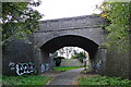
Bridge Road bridge from the Yarmouth side
The bridge is an arched constructed of engineering bricks and having wing walls. It has the designation number 2436.
Image: © Adrian S Pye
Taken: 27 Oct 2022
0.12 miles
7
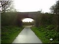
Gorleston path and former railway bridge
The trackbed of the Lowestoft to Great Yarmouth line (closed 1970) is now a walk in the southern parts of Gorleston. This roadbridge is the only one to exist from the former line in the Gorleston area. The trackbed further north being turned into a road with all traces now gone.
Image: © Ashley Dace
Taken: 19 Nov 2007
0.12 miles
8
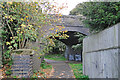
The bridge on Bridge Road
The embankment at Links Halt has now gradually diminished to the track being at normal ground level. The bridge is an arch constructed of engineering bricks and having wing walls. It has the designation number 2436.
Image: © Adrian S Pye
Taken: 27 Oct 2022
0.12 miles
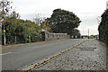
10
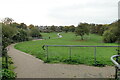
Looking back from south of the station
We are actually standing in (but a little higher than) the goods yard, between two of the sidings looking back along the line we have just travelled. The layout of the path here, deviates from the original line of the railway. The train-line ran a few yards to the left and was still 120 yards short of entering the station.
Image: © Adrian S Pye
Taken: 27 Oct 2022
0.13 miles