
IMAGES TAKEN NEAR TO
Townshend Close, GREAT YARMOUTH, NR30 2SG
Introduction
This page details the photographs taken nearby to Townshend Close, NR30 2SG by members of the Geograph project.
The Geograph project started in 2005 with the aim of publishing, organising and preserving representative images for every square kilometre of Great Britain, Ireland and the Isle of Man.

There are currently over 7.5m images from over14,400 individuals and you can help contribute to the project by visiting https://www.geograph.org.uk
Image Map
Images are licensed for reuse under creativecommons.org/licenses/by-sa/2.0
Notes
- Clicking on the map will re-center to the selected point.
- The higher the marker number, the further away the image location is from the centre of the postcode.
Image Listing (1059 Images Found)
Images are licensed for reuse under creativecommons.org/licenses/by-sa/2.0
Image
Details
Distance
1

Townshend Close, off Tolhouse Street
This was the location of Row 109. https://www.geograph.org.uk/article/Great-Yarmouths-Rows
Townshend Close forms part of the Middleton estate. Plans for a total revamp involving the demolition of 301 homes of the Middlegate estate were first discussed in 2018. The estate, which extends over an area of streets from Yarmouth Way to Friars Lane, currently comprises 535 homes (478 council rented homes and 57 in private ownership). According to the report, there would be 623 homes in total, after regeneration. The total cost of the scheme is listed as £113,417,070 and the project is said to leave a net gain of 32 extra council rented homes in the area.
Image: © Evelyn Simak
Taken: 22 Oct 2018
0.00 miles
2

Townshend Close, off Tolhouse Street
The entrance passages to rows 119 and 110 can be seen in the background to the left and the right of the white house. https://www.geograph.org.uk/article/Great-Yarmouths-Rows
Image: © Evelyn Simak
Taken: 22 Oct 2018
0.01 miles
3

Great Yarmouth's Rows - Row 116 (Sam Hurry's Row)
Short alley linking with Row 113 and leading to Townshend Close, which may not have existed when the rows were still in place. https://www.geograph.org.uk/article/Great-Yarmouths-Rows
Image: © Evelyn Simak
Taken: 22 Oct 2018
0.02 miles
4

Great Yarmouth's Rows - Row 109 (Red Lion Row)
View west. https://www.geograph.org.uk/article/Great-Yarmouths-Rows
Image: © Evelyn Simak
Taken: 10 Oct 2018
0.02 miles
5

Great Yarmouth's Rows - Row 109 (Red Lion Row)
View east. https://www.geograph.org.uk/article/Great-Yarmouths-Rows
Image: © Evelyn Simak
Taken: 22 Oct 2018
0.02 miles
6

Great Yarmouth's Rows - Row 109 (Red Lion Row)
View east towards King Street. https://www.geograph.org.uk/article/Great-Yarmouths-Rows
Image: © Evelyn Simak
Taken: 25 Oct 2018
0.02 miles
7

Great Yarmouth's Rows - Row 110 (Perry the Oatmeal Maker's Row)
View west. https://www.geograph.org.uk/article/Great-Yarmouths-Rows
Image: © Evelyn Simak
Taken: 10 Oct 2018
0.02 miles
8

Great Yarmouth's Rows - Row 113 (Tilson's Row)
View west. https://www.geograph.org.uk/article/Great-Yarmouths-Rows
Image: © Evelyn Simak
Taken: 10 Oct 2018
0.02 miles
9
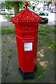
Penfold postbox
One of a pair of National Standard postboxes in Yarmouth designed by J.W. Penfold and produced between 1866-1879. Both have been relocated within the town; this one is just off King Street.
Image: © Tiger
Taken: 8 Aug 2009
0.02 miles
10

The Michael Blank Hut
By the entrance to Townshend Close. For a view of its name sign see > http://www.geograph.org.uk/photo/5953472.
Townshend Close forms part of the Middleton estate. Plans for a total revamp involving the demolition of 301 homes of the Middlegate estate were first discussed in 2018. The estate, which extends over an area of streets from Yarmouth Way to Friars Lane, currently comprises 535 homes (478 council rented homes and 57 in private ownership). According to the report, there would be 623 homes in total, after regeneration. The total cost of the scheme is listed as £113,417,070 and the project is said to leave a net gain of 32 extra council rented homes in the area.
Image: © Evelyn Simak
Taken: 25 Oct 2018
0.02 miles