
IMAGES TAKEN NEAR TO
York Road, GREAT YARMOUTH, NR30 2NA
Introduction
This page details the photographs taken nearby to York Road, NR30 2NA by members of the Geograph project.
The Geograph project started in 2005 with the aim of publishing, organising and preserving representative images for every square kilometre of Great Britain, Ireland and the Isle of Man.

There are currently over 7.5m images from over14,400 individuals and you can help contribute to the project by visiting https://www.geograph.org.uk
Image Map
Images are licensed for reuse under creativecommons.org/licenses/by-sa/2.0
Notes
- Clicking on the map will re-center to the selected point.
- The higher the marker number, the further away the image location is from the centre of the postcode.
Image Listing (836 Images Found)
Images are licensed for reuse under creativecommons.org/licenses/by-sa/2.0
Image
Details
Distance
1
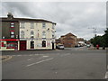
Colonel H, Nelson Road Central, NR30 2JY
Situated at the corner of Rodney Road. Formerly the Lancaster Tavern the pub takes its name from Lt. Colonel Herbert Jones who died in the Falkland Islands war in 1982 and was awarded the Victoria Cross posthumously.
Image: © Peter Holmes
Taken: 17 Jun 2015
0.05 miles

3
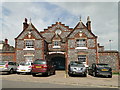
The Drill House, Great Yarmouth
The Drill House or Hall is a grade II listed building built in 1867 with the foundation stone laid on may 24th by Capt B.P. Youell, the Mayor of Yarmouth at the time.
It was bought from the Borough Council and is currently in use as a Performing Arts centre called Seachange Arts who encourage and run workshops for street artists and circus performers.
For a view of the interior see > http://www.geograph.org.uk/photo/4568945
Image: © Adrian S Pye
Taken: 14 Jul 2015
0.05 miles
4
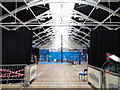
The interior of the Great Yarmouth Drill House
For the exterior view and more details go to > http://www.geograph.org.uk/photo/4568941
Image: © Adrian S Pye
Taken: 14 Jul 2015
0.05 miles
5

The first house in WW1 to be bombed by a Zeppelin
The house is on St. Peter's Plain, in Great Yarmouth, and it is recognised as receiving the first direct hit on 19th January 1915 from a Zeppelin Airship.
Samuel Arthur Smith and Martha Taylor were killed. Martha Taylor's grave at Caister can be seen here http://www.geograph.org.uk/photo/5011925
and Samuel Smith's here http://www.geograph.org.uk/photo/5818430
The blue wall plaque can be seen here http://www.geograph.org.uk/photo/5817751 .
Image: © Adrian S Pye
Taken: 24 Jun 2018
0.06 miles
6

Blue plaque in recognition of the first Zeppelin raid on the UK
See http://www.geograph.org.uk/photo/5817749 for more details.
Image: © Adrian S Pye
Taken: 24 Jun 2018
0.06 miles
7

'Quality used cars'
A side view of the small Golden Horseshoes garage, which has the air of not being a going concern anymore.
Image: © Robin Webster
Taken: 14 Aug 2018
0.07 miles
8

Ordnance Survey Cut Bench Mark
Ordnance Survey Cut Bench Mark
Image: © Mat Tuck
Taken: 24 Oct 2014
0.07 miles
9

St Spyridon's church, Great Yarmouth
This is the former St Peter's church, built in 1830. It currently serves the Greek Orthodox community.
Image: © Evelyn Simak
Taken: 8 May 2011
0.07 miles
10

St Spyridon's church, Great Yarmouth
This is the former St Peter's church, built in 1830. It currently serves the Greek Orthodox community.
Image: © Evelyn Simak
Taken: 8 May 2011
0.07 miles