
IMAGES TAKEN NEAR TO
Northgate Street, GREAT YARMOUTH, NR30 1BU
Introduction
This page details the photographs taken nearby to Northgate Street, NR30 1BU by members of the Geograph project.
The Geograph project started in 2005 with the aim of publishing, organising and preserving representative images for every square kilometre of Great Britain, Ireland and the Isle of Man.

There are currently over 7.5m images from over14,400 individuals and you can help contribute to the project by visiting https://www.geograph.org.uk
Image Map
Images are licensed for reuse under creativecommons.org/licenses/by-sa/2.0
Notes
- Clicking on the map will re-center to the selected point.
- The higher the marker number, the further away the image location is from the centre of the postcode.
Image Listing (31 Images Found)
Images are licensed for reuse under creativecommons.org/licenses/by-sa/2.0
Image
Details
Distance
1
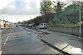
Beaconsfield Road, Great Yarmouth
On the right of the image, where the cars are parked was the Great Yarmouth to Lowestoft railway line elevated at this point having come off the Caister Road bridge. Beginning a descent at this point down a gradient of 1 in 106, which by the end of this road would have been on level ground to round the corner into North Denes Road.
Image: © Adrian S Pye
Taken: 4 Nov 2022
0.09 miles
2
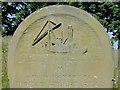
Detail of the headstone of Robert Thomas Read
The carved image probably represents the Steam Tug 'United Service'. It was from that vessel that he was drowned on 23rd December 1903, aged 69.
Image: © Adrian S Pye
Taken: 28 Jun 2016
0.10 miles
3
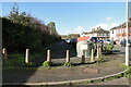
Beaconsfield Road car park on the former railway line
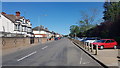
The line at this point would still be about the height of the wall on the left at this point having dropped from 16 feet at the top of the road to about ten.
Image: © Adrian S Pye
Taken: 4 Nov 2022
0.10 miles
4
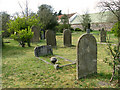
Kitchener Road Cemetery, Great Yarmouth
The cemetery is bordered by St Nicholas' church and priory in the south and by Nelson Road North in the east. The old cemetery is separated from the new cemetery by Kitchener Road which bisects the two. To the west, the new cemetery is bordered by Belvidere Road whereas East Road runs along the boundary of the old cemetery. Estcourt Road runs along the northern boundary of the new cemetery.
Image: © Evelyn Simak
Taken: 10 Apr 2011
0.10 miles
5
Kitchener Road Cemetery, Great Yarmouth
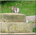
This young squirrel is investigating a bit of steel that is sticking out of the plinth of a toppled monument. The squirrels in the cemetery are quite tame and are waiting to be fed with peanuts.
The cemetery is bordered by St Nicholas' church and priory in the south and by Nelson Road North in the east. The old cemetery is separated from the new cemetery by Kitchener Road which bisects the two. To the west, the new cemetery is bordered by Belvidere Road whereas East Road runs along the boundary of the old cemetery. Estcourt Road runs along the northern boundary of the new cemetery.
Image: © Evelyn Simak
Taken: 10 Apr 2011
0.10 miles
6
Nearing the bottom of the incline
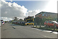
The track here would almost be flat and turn just after the last car to round the curve and enter the final leg
Image: © Adrian S Pye
Taken: 4 Nov 2022
0.10 miles
8
Kitchener Road Cemetery, Great Yarmouth
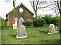
One of two chapels in this cemetery, this one is situated by the northern boundary wall of the new cemetery. The cemetery is bordered by St Nicholas' church and priory in the south and by Nelson Road North in the east. The old cemetery is separated from the new cemetery by Kitchener Road which bisects the two. To the west, the new cemetery is bordered by Belvidere Road whereas East Road runs along the boundary of the old cemetery. Estcourt Road runs along the northern boundary of the new cemetery.
Image: © Evelyn Simak
Taken: 10 Apr 2011
0.11 miles
9
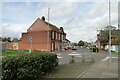
The site of the former Caister Road railway bridge
The bridge was of plate girder and brick construction with a 16 feet of clearance below. Until now the track has been on an embankment since Cobholm Island but the track after the bridge (to the right) is elevated and drops to ground level by the end of Beaconsfield Road on a 1 in 106 gradient.
Image: © Adrian S Pye
Taken: 8 Nov 2022
0.12 miles
10
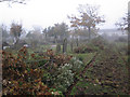
New Cemetery, Great Yarmouth
There is significant clearance work being done to improve sightlines, to reduce problems of drug takers and rough sleepers.
Image: © Hugh Venables
Taken: 23 Oct 2012
0.12 miles