IMAGES TAKEN NEAR TO
Clint Street, GREAT YARMOUTH, NR29 5PA
Introduction
This page details the photographs taken nearby to Clint Street, NR29 5PA by members of the Geograph project.
The Geograph project started in 2005 with the aim of publishing, organising and preserving representative images for every square kilometre of Great Britain, Ireland and the Isle of Man.

There are currently over 7.5m images from over14,400 individuals and you can help contribute to the project by visiting https://www.geograph.org.uk
Image Map
Images are licensed for reuse under creativecommons.org/licenses/by-sa/2.0
Notes
- Clicking on the map will re-center to the selected point.
- The higher the marker number, the further away the image location is from the centre of the postcode.
Image Listing (8 Images Found)
Images are licensed for reuse under creativecommons.org/licenses/by-sa/2.0
Image
Details
Distance
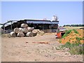
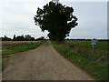
3
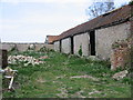
Derelict building and old wood, near How Hill
I was intrigued by the marking of "Thornton via Goole" - something ex-railway perhaps? The farm buildings are long disused.
Image: © Katy Walters
Taken: 4 Jul 2006
0.15 miles
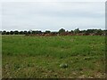
7
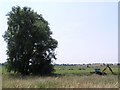
Grazing marshes, near How Hill
From the footpath near The Limes. It must be dyke-clearing season as the excavators seem to be everywhere.
Image: © Katy Walters
Taken: 4 Jul 2006
0.20 miles