IMAGES TAKEN NEAR TO
Edward Road, GREAT YARMOUTH, NR29 4BX
Introduction
This page details the photographs taken nearby to Edward Road, NR29 4BX by members of the Geograph project.
The Geograph project started in 2005 with the aim of publishing, organising and preserving representative images for every square kilometre of Great Britain, Ireland and the Isle of Man.

There are currently over 7.5m images from over14,400 individuals and you can help contribute to the project by visiting https://www.geograph.org.uk
Image Map
Images are licensed for reuse under creativecommons.org/licenses/by-sa/2.0
Notes
- Clicking on the map will re-center to the selected point.
- The higher the marker number, the further away the image location is from the centre of the postcode.
Image Listing (6 Images Found)
Images are licensed for reuse under creativecommons.org/licenses/by-sa/2.0
Image
Details
Distance
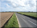
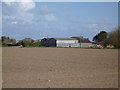
1
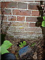
OS benchmark - High Barn Farm building
A shallow OS cutmark in the bricks of a barn at High Barn Farm; originally levelled at 17.071m above Ordnance Datum Newlyn.
Image: © Richard Law
Taken: 11 Sep 2013
0.05 miles
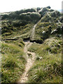
4
View down into The Valley
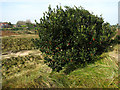
... and from there upwards again to the ridge where the lighthouse stands. The tree in the foreground is a female Holly tree laden with red berries. The holly is a tree which is both a broadleaf and an evergreen. The plant is a native shrub or small tree throughout the UK except for Caithness, Orkney and Shetland. Holly is normally dioecious, which means that there are separate male and female plants. The female plants produces berries in October. When growing in the wild, trees are usually 20 or more years old before they start producing berries. Holly berries are an important food source for many birds. For a more detailed view see > Image
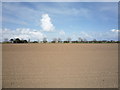
The coastline at Winterton is historically known to be one of the most hazardous parts of the British coastline. On visiting Winterton-on-Sea in 1722, Daniel Defoe commented that all the houses of the village were constructed from the timbers of wrecked ships. In order to stabilise the coastline against erosion marram grass was planted and by the early 19th century dunes had built up, forming a barrier between the high water mark and the ridge on which the lighthouse stands. During the second half of the 20th century the coastline has again changed in that some of the dunes eroded. The area is mostly situated at approximately sea level and erosion and flooding are constant potential risks to the village.
Image: © Evelyn Simak
Taken: 11 Oct 2007
0.19 miles