
IMAGES TAKEN NEAR TO
Seagull Road, GREAT YARMOUTH, NR29 3NY
Introduction
This page details the photographs taken nearby to Seagull Road, NR29 3NY by members of the Geograph project.
The Geograph project started in 2005 with the aim of publishing, organising and preserving representative images for every square kilometre of Great Britain, Ireland and the Isle of Man.

There are currently over 7.5m images from over14,400 individuals and you can help contribute to the project by visiting https://www.geograph.org.uk
Image Map
Images are licensed for reuse under creativecommons.org/licenses/by-sa/2.0
Notes
- Clicking on the map will re-center to the selected point.
- The higher the marker number, the further away the image location is from the centre of the postcode.
Image Listing (30 Images Found)
Images are licensed for reuse under creativecommons.org/licenses/by-sa/2.0
Image
Details
Distance

2

Shark egg case
Some of the shark species that live in British waters lay eggs and their empty egg cases can be found washed up on beaches. The Shark Trust records these egg cases because they are an easily accessible source of information of skate and ray nursery grounds. The identification of these critical areas will enable the Shark Trust to propose conservation measures.
http://www.eggcase.org/view_folder.asp?folderid=6251&level2id=6237&rootid=6237&depth=2&level1=&toptab=2
Image: © Evelyn Simak
Taken: 4 Nov 2007
0.07 miles
3

Homes on The Esplanade
The Esplanade is an unsurfaced access road to the houses above Scratby beach. There are no car parking facilities but walkers are welcomed, as long as they stay on the marked paths and clean up after their dogs. There are several paths that allow access to the beach.
Image: © Evelyn Simak
Taken: 4 Nov 2007
0.08 miles
4
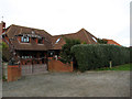
House at the end of The Esplanade
See > Image The Esplanade is an unsurfaced access road to the houses above Scratby beach. There are no car parking facilities but walkers are welcomed, as long as they stay on the marked paths and clean up after their dogs. There are several paths that allow access to the beach, cutting across the grassed-over strip between The Esplanade and the dunes.
Image: © Evelyn Simak
Taken: 4 Nov 2007
0.08 miles
5

Wave patterns
... created by the receding waters of the outgoing tide.
Image: © Evelyn Simak
Taken: 4 Nov 2007
0.09 miles
6
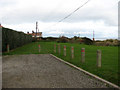
Where The Esplanade ends
The Esplanade is an unsurfaced access road to the houses above Scratby beach. There are no car parking facilities but walkers are welcomed, as long as they stay on the marked paths and clean up after their dogs. There are several paths that allow access to the beach, cutting across the grassed-over strip between The Esplanade and the dunes. At the end of the access road a path continues in northwesterly direction, leading further along the coastline: Image
Image: © Evelyn Simak
Taken: 4 Nov 2007
0.09 miles

8

Looking SE on Scratby Beach
Addendum: a six metre wide strip of dunes has been scoured away by the tide waters on occasion of the unusually high surge of the North Sea along the east coast, caused by high winds, on 9th November 2007; the cliffs remained unscathed thanks to a rock berm.
Image: © Evelyn Simak
Taken: 4 Nov 2007
0.11 miles

10
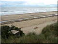
Anti-invasion defences from WWII
The concrete structures seen in the foreground and on the beach may be all that remains of a coast guard lookout point, erected in 1940/41 at the edge of the dunes as part of the coastal crust defences. The structures consisted of a concrete slab measuring about 3 x 3 metres, mounted on concrete blocks; one was erected on the cliff edge, the other one in front of it down on the beach. Defence of Britain database ID: S0009103
During World War II, the beaches in the area were extensively protected by erecting a number of anti-invasion defences such as barriers of scaffolding, anti-tank cubes, pillboxes and gun emplacements. Exposed by wind and sea water, these constructions can usually be found at the bottom of a dune.
Addendum: a six metre wide strip of dunes has been scoured away by the tide waters on occasion of the unusually high surge of the North Sea along the east coast, caused by high winds, on 9th November 2007; the cliffs remained unscathed thanks to a rock berm.
Image: © Evelyn Simak
Taken: 4 Nov 2007
0.12 miles