IMAGES TAKEN NEAR TO
Ormesby, GREAT YARMOUTH, NR29 3NA
Introduction
This page details the photographs taken nearby to NR29 3NA by members of the Geograph project.
The Geograph project started in 2005 with the aim of publishing, organising and preserving representative images for every square kilometre of Great Britain, Ireland and the Isle of Man.

There are currently over 7.5m images from over14,400 individuals and you can help contribute to the project by visiting https://www.geograph.org.uk
Image Map
Images are licensed for reuse under creativecommons.org/licenses/by-sa/2.0
Notes
- Clicking on the map will re-center to the selected point.
- The higher the marker number, the further away the image location is from the centre of the postcode.
Image Listing (6 Images Found)
Images are licensed for reuse under creativecommons.org/licenses/by-sa/2.0
Image
Details
Distance
1
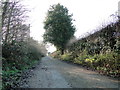
A track which is Burgh Wood Road at Rollesby
Burghwood Farm is at the far end
Image: © Adrian S Pye
Taken: 25 Dec 2018
0.18 miles
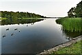
2
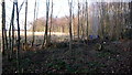
Rollesby Broad
Broads Authority volunteers clearing the reed beds of saplings.
Image: © Rob Walker
Taken: 30 Jan 2011
0.19 miles
3
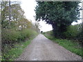
Track towards Burghwood Farm
Heading south west.
Image: © JThomas
Taken: 26 Apr 2016
0.19 miles
5
Ormesby St Michael, Ormesby Little Broad
Image: © Michael Garlick
Taken: 10 Jun 2023
0.23 miles
6
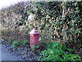
Unusual mail box in Burgh Wood Road (a Track)
Image: © Adrian S Pye
Taken: 25 Dec 2018
0.25 miles