IMAGES TAKEN NEAR TO
Mundesley Road, NORTH WALSHAM, NR28 0RE
Introduction
This page details the photographs taken nearby to Mundesley Road, NR28 0RE by members of the Geograph project.
The Geograph project started in 2005 with the aim of publishing, organising and preserving representative images for every square kilometre of Great Britain, Ireland and the Isle of Man.

There are currently over 7.5m images from over14,400 individuals and you can help contribute to the project by visiting https://www.geograph.org.uk
Image Map
Images are licensed for reuse under creativecommons.org/licenses/by-sa/2.0
Notes
- Clicking on the map will re-center to the selected point.
- The higher the marker number, the further away the image location is from the centre of the postcode.
Image Listing (95 Images Found)
Images are licensed for reuse under creativecommons.org/licenses/by-sa/2.0
Image
Details
Distance

3
Houses on the B1145
Viewed from the Quaker burial ground.
Image: © Evelyn Simak
Taken: 13 Sep 2008
0.04 miles
4
On Paston Way - View NE along disused railway track bed, N of N Walsham
Image: © Colin Park
Taken: 31 Jul 2013
0.05 miles
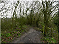
5
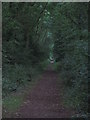
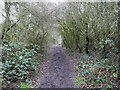
View northeast along the Paston Way
The view was taken through a disused railway bridge by the end of Mundesley Road.
Following the course of a dismantled railway line, the Paston Way takes its name from the Pastons - a landowning and merchant family during the Medieval and Tudor periods - who adopted their name from the small village of the same name, located on the north east coast of Norfolk > http://www.geograph.org.uk/photo/600798. The walk starts by the gates of Paston College > http://www.geograph.org.uk/photo/268662 in North Walsham, crossing the Market Place > http://www.geograph.org.uk/photo/617099 . Traversing the churchyard of St. Nicholas > http://www.geograph.org.uk/photo/772307 from the south it finishes in the church of St Peter and St Paul > http://www.geograph.org.uk/photo/873394 at Cromer. The Paston Way leads through sixteen villages and towns and links with the Weavers Way both at Cromer and North Walsham.
Image: © Evelyn Simak
Taken: 13 Sep 2008
0.05 miles
6
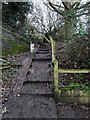
Steps up to the Paston Way from Little London Road
Image: © David Pashley
Taken: 29 Jan 2021
0.06 miles
7
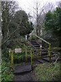
Steps from Little London Road to Paston Way on embankment
Image: © David Pashley
Taken: 29 Jan 2021
0.06 miles
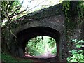
10
Path diversion
Path diverted as no Railway arch.
Image: © David Pashley
Taken: 29 Jan 2021
0.07 miles