IMAGES TAKEN NEAR TO
Meadow Way Drive, NORTH WALSHAM, NR28 0QQ

Introduction

This page details the photographs taken nearby to Meadow Way Drive, NR28 0QQ by members of the Geograph project.

The Geograph project started in 2005 with the aim of publishing, organising and preserving representative images for every square kilometre of Great Britain, Ireland and the Isle of Man.

There are currently over 7.5m images from over14,400 individuals and you can help contribute to the project by visiting https://www.geograph.org.uk

Image Map


Images are licensed for reuse under creativecommons.org/licenses/by-sa/2.0
Notes
  • Clicking on the map will re-center to the selected point.
  • The higher the marker number, the further away the image location is from the centre of the postcode.

Image Listing (331 Images Found)

Images are licensed for reuse under creativecommons.org/licenses/by-sa/2.0
  • ...
Image
Details
Distance
1
Passageway part of Paston Way
Image: © David Pashley Taken: 10 Jul 2021
0.03 miles
2
Chapel Rd, Trunch
Image: © N Chadwick Taken: 29 Dec 2013
0.04 miles
3
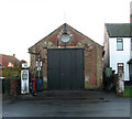
Former Methodist Chapel
In Chapel Road > http://www.geograph.org.uk/photo/1073770. At some stage this chapel was used as a garage, the old petrol pump > http://www.geograph.org.uk/photo/1073789 is still in its original place. The building appears not to be used at present.
Image: © Evelyn Simak Taken: 7 Dec 2008
0.04 miles
4
Chapel Road Trunch
Image: © David Pashley Taken: 10 Jul 2021
0.04 miles
5
Trunch Corner Stores and Post Office
Formerly the New Inn, later it seems to have been called The Corner House.
Image: © Robin Webster Taken: 26 Dec 2013
0.04 miles
6
Trunch Stores
Image: © N Chadwick Taken: 29 Dec 2013
0.04 miles
7
Trunch Corner Stores and Village Sign
Opposite St Botolph's Church.
Image: © G Laird Taken: 24 Oct 2017
0.04 miles
8
Village sign
The village sign is located in front of the village shop and post office > http://www.geograph.org.uk/photo/1073795. See > http://www.geograph.org.uk/photo/1073807 for a close-up view. Trunch is a small village with a population of about 800, located three miles north of North Walsham and two miles from the coast at Mundesley. The parish covers an area of 5.5 square kilometres. The village - dominated by St Botholph's church > http://www.geograph.org.uk/photo/1075202 - is set in an area of outstanding natural beauty and can trace its history back to 1066. The name Trunch is believed to derive from a Danish word which means 'weighing place' and a market is said to have been held there as late as the 16th century. There is a village store and post office, the Crown Inn, and a number of attractive houses and converted barns. Once there also used to be a large brewery which was built in 1837 by William Primrose, whose family used to live in the parish for three centuries - the brewery has since closed. In English folk music the fictional village of St Just-near-Trunch is famous for being the home of the satirical band called 'The Kipper Family'.
Image: © Evelyn Simak Taken: 7 Dec 2008
0.04 miles
9
Footpath in Trunch
Image: © N Chadwick Taken: 29 Dec 2013
0.04 miles
10
A vintage petrol pump
Old petrol pump in front of a former Methodist chapel > http://www.geograph.org.uk/photo/1073780 located in Chapel Road > http://www.geograph.org.uk/photo/1073770. At some stage it was converted for use as a garage and petrol filling station.
Image: © Evelyn Simak Taken: 7 Dec 2008
0.04 miles
  • ...