IMAGES TAKEN NEAR TO
Oak Close, NORTH WALSHAM, NR28 0BY
Introduction
This page details the photographs taken nearby to Oak Close, NR28 0BY by members of the Geograph project.
The Geograph project started in 2005 with the aim of publishing, organising and preserving representative images for every square kilometre of Great Britain, Ireland and the Isle of Man.

There are currently over 7.5m images from over14,400 individuals and you can help contribute to the project by visiting https://www.geograph.org.uk
Image Map
Images are licensed for reuse under creativecommons.org/licenses/by-sa/2.0
Notes
- Clicking on the map will re-center to the selected point.
- The higher the marker number, the further away the image location is from the centre of the postcode.
Image Listing (84 Images Found)
Images are licensed for reuse under creativecommons.org/licenses/by-sa/2.0
Image
Details
Distance
1
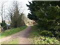
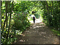
Weavers Way heading towards North Walsham
Image: © David Pashley
Taken: 23 Feb 2021
0.02 miles
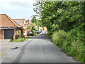
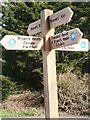
4
Weavers' Way near North Walsham
Named after the Flanders weavers who settled here in the 12th century, the 99km route lies between Cromer and Great Yarmouth. Here the path follows a former railway route.
Image: © Jim Barton
Taken: 4 Jul 2024
0.05 miles