IMAGES TAKEN NEAR TO
Roman Camp, CROMER, NR27 9ND
Introduction
This page details the photographs taken nearby to Roman Camp, NR27 9ND by members of the Geograph project.
The Geograph project started in 2005 with the aim of publishing, organising and preserving representative images for every square kilometre of Great Britain, Ireland and the Isle of Man.

There are currently over 7.5m images from over14,400 individuals and you can help contribute to the project by visiting https://www.geograph.org.uk
Image Map
Images are licensed for reuse under creativecommons.org/licenses/by-sa/2.0
Notes
- Clicking on the map will re-center to the selected point.
- The higher the marker number, the further away the image location is from the centre of the postcode.
Image Listing (93 Images Found)
Images are licensed for reuse under creativecommons.org/licenses/by-sa/2.0
Image
Details
Distance
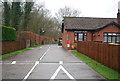
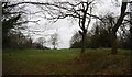
2
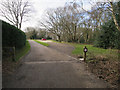
Entrance to Roman Camp caravan park
An empty pay and display National Trust car park can be seen in the foreground.
Image: © Evelyn Simak
Taken: 19 Dec 2008
0.00 miles
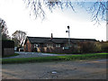
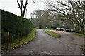
5
Car park for Beacon Hill
At the end of Camp Lane.
Image: © Hugh Venables
Taken: 29 Mar 2016
0.03 miles
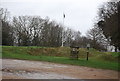
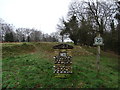
10
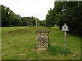
Beacon Hill
Highest point in Norfolk.
Image: © Roger Cornfoot
Taken: 20 Jun 2019
0.04 miles