IMAGES TAKEN NEAR TO
Chesterfield Cottages, West Street, CROMER, NR27 9ED
Introduction
This page details the photographs taken nearby to Chesterfield Cottages, West Street, NR27 9ED by members of the Geograph project.
The Geograph project started in 2005 with the aim of publishing, organising and preserving representative images for every square kilometre of Great Britain, Ireland and the Isle of Man.

There are currently over 7.5m images from over14,400 individuals and you can help contribute to the project by visiting https://www.geograph.org.uk
Image Map
Images are licensed for reuse under creativecommons.org/licenses/by-sa/2.0
Notes
- Clicking on the map will re-center to the selected point.
- The higher the marker number, the further away the image location is from the centre of the postcode.
Image Listing (602 Images Found)
Images are licensed for reuse under creativecommons.org/licenses/by-sa/2.0
Image
Details
Distance
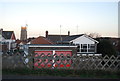
1
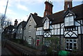
Chesterfield Villas
Grade II listed. http://www.britishlistedbuildings.co.uk/en-222562-chesterfield-villas-cromer-norfolk
Image: © N Chadwick
Taken: 28 Dec 2013
0.02 miles
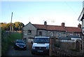
6
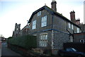
Chesterfield Lodge
Grade II listed. http://www.britishlistedbuildings.co.uk/en-222561-chesterfield-lodge-cromer-norfolk
Image: © N Chadwick
Taken: 28 Dec 2013
0.02 miles
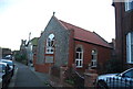
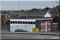
8
Cromer Fire Station seen from Beach Road
Image: © Basher Eyre
Taken: 14 Apr 2017
0.03 miles
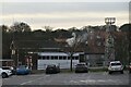
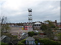
10
Looking east-northeast along Holt Road
Image: © Basher Eyre
Taken: 14 Apr 2017
0.03 miles