
IMAGES TAKEN NEAR TO
Howards Hill, CROMER, NR27 9BL
Introduction
This page details the photographs taken nearby to Howards Hill, NR27 9BL by members of the Geograph project.
The Geograph project started in 2005 with the aim of publishing, organising and preserving representative images for every square kilometre of Great Britain, Ireland and the Isle of Man.

There are currently over 7.5m images from over14,400 individuals and you can help contribute to the project by visiting https://www.geograph.org.uk
Image Map
Images are licensed for reuse under creativecommons.org/licenses/by-sa/2.0
Notes
- Clicking on the map will re-center to the selected point.
- The higher the marker number, the further away the image location is from the centre of the postcode.
Image Listing (245 Images Found)
Images are licensed for reuse under creativecommons.org/licenses/by-sa/2.0
Image
Details
Distance
1

Cut Mark No 31/33 Westcliffe Ave Cromer
Image: © Monica Stagg
Taken: 9 Jul 2015
0.07 miles
2

View towards the top of Howard's Hill
The turnoff seen at top left leads to > Image; the junction seen in the foreground is with Shipden Avenue > http://www.geograph.org.uk/photo/838913. See > http://www.geograph.org.uk/photo/838922 for a view in the opposite direction.
Image: © Evelyn Simak
Taken: 10 Jun 2008
0.08 miles
3

Howards Hill
Looking down a residential street to the west of Cromer.
Image: © DS Pugh
Taken: 28 Aug 2007
0.09 miles
4

Zoo Lodge
The entrance to the former Cromer Zoo is still in place, 20 years after its closure. The zoo was owned by circus man Alex Kerr, who in 1960, after his retirement, had brought with him many of the animals with which he had worked. Continued by his widow, the collection was broadened and because many of the animals were large and the acreage was small, the place was crowded. The zoo was closed in 1983.
Image: © Evelyn Simak
Taken: 10 Jun 2008
0.09 miles

6

View west along railway line
At the end of the platform at Cromer railway station.
Image: © Evelyn Simak
Taken: 19 Dec 2008
0.10 miles
7
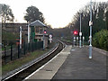
Evening on Cromer station
Waiting for the 15:57 to Norwich to arrive from Sheringham. The train reverses here. The signal box and all behind the railings on the left are non-functional and preserved. The colour-light signals are numbered TB32 and TB34, the 'TB' indicating they are controlled from Trowse Swing Bridge box, at the Norwich end of what is now marketed as the 'Bittern Line'.
Image: © Robin Webster
Taken: 27 Dec 2013
0.10 miles

9

Cromer Signal Box
The Midland & Great Northern Joint Railway signal box (no longer in use, but a listed building) is built of concrete blocks, the favourite building material of the line's resourceful engineer, William Marriott.
Image: © John Sutton
Taken: Unknown
0.11 miles
