IMAGES TAKEN NEAR TO
Church Street, CROMER, NR27 0AA
Introduction
This page details the photographs taken nearby to Church Street, NR27 0AA by members of the Geograph project.
The Geograph project started in 2005 with the aim of publishing, organising and preserving representative images for every square kilometre of Great Britain, Ireland and the Isle of Man.

There are currently over 7.5m images from over14,400 individuals and you can help contribute to the project by visiting https://www.geograph.org.uk
Image Map
Images are licensed for reuse under creativecommons.org/licenses/by-sa/2.0
Notes
- Clicking on the map will re-center to the selected point.
- The higher the marker number, the further away the image location is from the centre of the postcode.
Image Listing (82 Images Found)
Images are licensed for reuse under creativecommons.org/licenses/by-sa/2.0
Image
Details
Distance
1
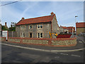
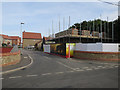
Gallus Fields
New housing development in Northrepps.
Image: © Hugh Venables
Taken: 13 Sep 2016
0.02 miles
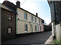
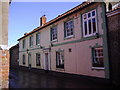
4
Church Lane, Northrepps
The Foundry Arms is on the left.
Image: © Julian P Guffogg
Taken: 22 May 2019
0.03 miles
6
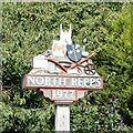
North Repps village sign
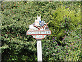
A glorious celebration of the history of the village, from the church of St. Mary at the top, A shield with pierced winged heart. The crest of St. Benet’s Abbey represents not the abbey but the last abbot, a William Ruggs was born in the village. A man, upper left is seen wearing a breeches buoy reminds us that Anna Gurney who lived at Northrepps Hall, invented the concept and funded the installation of a breeches buoy. A barrel next to a groin represents the smuggling which once confounded the revenue men along the coast, sits on the railway bridge over New Road. Henry Royce designed the Silver Ghost here whilst convalescing at the Hall, hence the Rolls Royce radiator grill. Beneath that is a cithern, a lute-like instrument which John Playford of Northrepps played and wrote a book about in 1652. Next to that are the shackles of a released slave, thanks in part to Sir Thomas Fowell Buxton who, in 1822, succeeded William Wilberforce as leader of the campaign in the House of Commons for the abolition of slavery. He too lived at the Northrepps Hall. The poppy remembers those who died in the 20th century wars and the plough is no ordinary plough, it is a Gallas plough invented and developed in The Foundry at Northrepps in 1830.
https://www.geograph.org.uk/photo/4602752
Image: © Adrian S Pye
Taken: 7 Aug 2015
0.04 miles
8
Northrepps village sign
For a closer look see here > http://www.geograph.org.uk/photo/4602752
Image: © Adrian S Pye
Taken: 7 Aug 2015
0.04 miles
9
Northrepps village sign
Usually written as one word but as two words here.
A glorious celebration of the history of the village, from the church of St. Mary at the top, A shield with pierced winged heart. The crest of St. Benet’s Abbey represents not the abbey but the last abbot, a William Ruggs was born in the village. A man, upper left is seen wearing a breeches buoy reminds us that Anna Gurney who lived at Northrepps Hall, invented the concept and funded the installation of a breeches buoy. A barrel next to a groin represents the smuggling which once confounded the revenue men along the coast, sits on the railway bridge over New Road. Henry Royce designed the Silver Ghost here whilst convalescing at the Hall, hence the Rolls Royce radiator grill. Beneath that is a cithern, a lute-like instrument which John Playford of Northrepps played and wrote a book about in 1652. Next to that are the shackles of a released slave, thanks in part to Sir Thomas Fowell Buxton who, in 1822, succeeded William Wilberforce as leader of the campaign in the House of Commons for the abolition of slavery. He too lived at the Northrepps Hall. The poppy remembers those who died in the 20th century wars and the plough is no ordinary plough, it is a Gallas plough invented and developed in The Foundry at Northrepps in 1830. https://www.geograph.org.uk/photo/6674136
Image: © Adrian S Pye
Taken: 7 Aug 2015
0.04 miles
10
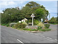
Northrepps Village Sign
The town's name on the sign is shown as North Repps and dated 1977. It is located at the corner of Nut Lane and Bull's Row.
Image: © G Laird
Taken: 24 Oct 2017
0.04 miles